South Carolina Highway 263
South Carolina Highway 263 (SC 263) is a 5 1⁄4-mile-long (8.4 km) state highway in the U.S. state of South Carolina. The highway connects Eastover with rural areas of Richland County.
| ||||
|---|---|---|---|---|
| ||||
| Route information | ||||
| Maintained by SCDOT | ||||
| Length | 5.25 mi[1] (8.45 km) | |||
| Major junctions | ||||
| South end | ||||
| North end | ||||
| Location | ||||
| Counties | Richland | |||
| Highway system | ||||
| ||||

Route description
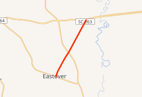
SC 263 begins at an intersection with SC 764 (Main Street) in Eastover, Richland County. It travels to the northeast and leaves the city limits. The highway crosses Griffin Creek. Approximately 2,500 feet (760 m) later, it intersects U.S. Route 601 (US 601; McCords Ferry Road). Farther to the northeast, it meets its northern terminus, an intersection with US 76/US 378 (Garners Ferry Road).[2]
Major intersections
The entire route is in Richland County.
| Location | mi[2] | km | Destinations | Notes | |
|---|---|---|---|---|---|
| Eastover | 0.00 | 0.00 | |||
| | 2.22 | 3.57 | |||
| | 5.25 | 8.45 | |||
| 1.000 mi = 1.609 km; 1.000 km = 0.621 mi | |||||
gollark: Suuuure.
gollark: Like how "apioid" means "beelike entity".
gollark: * citrons lispoid™
gollark: Too bad, exploiting memory unsafety in citrons lisp™ to load arbitrary code and enter long mode...
gollark: Apparently. Anyway, you ARE to enter long mode for ???.
See also


References
- "Statewide Highways (shapefile)" (zip). South Carolina Department of Transportation. September 29, 2017. Retrieved December 8, 2017.
- Google (May 12, 2016). "South Carolina Highway 263" (Map). Google Maps. Google. Retrieved May 12, 2016.
External links

- SC 263 South Carolina Hwy Index
This article is issued from Wikipedia. The text is licensed under Creative Commons - Attribution - Sharealike. Additional terms may apply for the media files.