South Carolina Highway 182
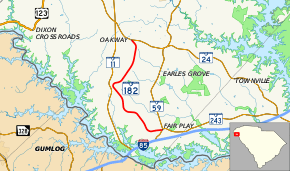
South Carolina Highway 182 (SC 182) is a 9.6-mile-long (15.4 km) state highway in the U.S. state of South Carolina. The highway connects Fair Play and Oakway.
| ||||
|---|---|---|---|---|
 | ||||
| Route information | ||||
| Maintained by SCDOT | ||||
| Length | 9.58 mi[1] (15.42 km) | |||
| Major junctions | ||||
| South end | ||||
| North end | ||||
| Location | ||||
| Counties | Oconee | |||
| Highway system | ||||
| ||||

Route description
SC 182 begins at an intersection with SC 59 and SC 243 (Fair Play Boulevard) in Fair Play, within Oconee County. It travels to the west-southwest and almost immediately curves to the north-northwest. The highway curves to the northeast and enters Oakway. Just before passing the Oakway Intermediate School, it curves to the northwest. A short distance later, it meets its northern terminus, an intersection with SC 24 (West Oak Highway).[2]
Major intersections
The entire route is in Oconee County.
| Location | mi[1] | km | Destinations | Notes | |
|---|---|---|---|---|---|
| Fair Play | 0.00 | 0.00 | Southern terminus | ||
| Oakway | 9.58 | 15.42 | Northern terminus | ||
| 1.000 mi = 1.609 km; 1.000 km = 0.621 mi | |||||
gollark: I wonder if you could randomize the data it uses to fingerprint without breaking anything too badly. Though I guess "this is random" would be a strong signal itself.
gollark: Would it not show those as different OSes?
gollark: I should add this to my website.
gollark: And so can some governments.
gollark: Of course, they *can*, and so could anyone else if it was ever leaked somehow.
See also


References
- "Statewide Highways (shapefile)" (zip). South Carolina Department of Transportation. September 29, 2017. Retrieved December 8, 2017.
- Google (May 9, 2016). "South Carolina Highway 182" (Map). Google Maps. Google. Retrieved May 9, 2016.
External links

- SC 182 - South Carolina Hwy Index Home
This article is issued from Wikipedia. The text is licensed under Creative Commons - Attribution - Sharealike. Additional terms may apply for the media files.