South Holland
South Holland (Dutch: Zuid-Holland [ˌzœyt ˈɦɔlɑnt] (![]()
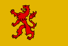
South Holland Zuid-Holland | |
|---|---|
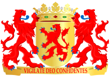 Coat of arms | |
| Motto(s): "Vigilate Deo confidentes" (Latin) "Watch, trusting in God" | |
| Anthem: "Lied van Zuid-Holland" (Dutch) "Song of South Holland" | |
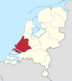 Location of South Holland in the Netherlands | |
 | |
| Coordinates: 52°00′N 4°40′E | |
| Country | |
| Established | 1840 (split-up of Holland) |
| Capital | The Hague |
| Largest city | Rotterdam |
| Government | |
| • King's Commissioner | Jaap Smit (CDA) |
| Area (2020)[1] | |
| • Total | 3,307.86 km2 (1,277.17 sq mi) |
| • Land | 2,700.07 km2 (1,042.50 sq mi) |
| • Water | 607.79 km2 (234.67 sq mi) |
| Area rank | 6th |
| Population (1 January 2020)[2] | |
| • Total | 3,707,964 |
| • Rank | 1st |
| • Density | 1,373/km2 (3,560/sq mi) |
| • Density rank | 1st |
| ISO 3166 code | NL-ZH |
| GDP (nominal)[3] | 2016 |
| - Total | €151 billion/ USD 160 billion |
| - Per capita | €41,000/ USD 44,000[4] |
| HDI (2017) | 0.932[5] very high · 3rd |
| Website | www.zuid-holland.nl |
History
Early history
Archaeological discoveries in Hardinxveld-Giessendam indicate that the area of South Holland has been inhabited since at least ca. 7,500 years before present, probably by nomadic hunter-gatherers. Agriculture and permanent settlements probably originated around 2,000 years later, based on excavations near Vlaardingen. In the classical antiquity, South Holland was part of the Roman Province of Germania Inferior, and the border of the Roman Empire ran along the Old Rhine and reached the North Sea near Katwijk. The Romans built fortresses along the border, such as Praetorium Agrippinae near modern-day Valkenburg, Matilo near modern-day Leiden, and Albaniana near modern-day Alphen aan den Rijn. A city was founded near modern-day Voorburg, Forum Hadriani. It was built according to the grid plan, and facilitated a square, a court, a bathhouse and several temples.
After the departure of the Romans, the area belonged to the Frisian Kingdom, after which it was conquered by the Frankish king Dagobert I in 636. In 690, the Anglo-Saxon monk Willibrord arrived near Katwijk and was granted permission to spread Roman Catholicism by the Frankish king Pepin II. He accordingly founded a church in Oegstgeest, after which the entire area was gradually Christianised. The area was appointed to East Francia in the Treaty of Verdun in 843, after which the king granted lands to Gerolf, who had helped him claim the lands. This was the birth of the County of Holland. Gerolf was later succeeded by Dirk I, who continued to rule Holland under the Frankish king. In 1248, count William II ordered the construction of the Ridderzaal, which was later finished by his son and successor Floris V.
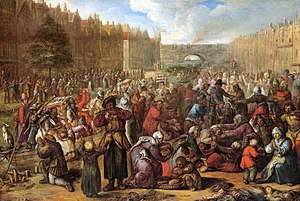
The first city in South Holland to receive city rights was Dordrecht, which did so in 1220. The city retained a dominant position in the area until it was struck by a series of floods in the late 14th century. The same century also saw a series of civil wars, the Hook and Cod wars, concerning the succession of count William IV. Both his daughter Jacqueline and his brother John, the latter supported by Philip the Good, Duke of Burgundy, claimed the throne. The conflict ended in 1490, with John victorious.
Overall, the area of South Holland remained largely agrarian throughout the late Middle Ages. This changed around 1500, when Holland became Europe's most urbanised area. During the Eighty Years' War, the area of South Holland was the scene of the Capture of Brielle, the Siege of Leiden and the assassination of William the Silent.
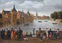
The United Netherlands declared their independence in 1581, and Holland quickly emerged as the country's dominant province, with important trading cities such as Leiden, Delft, Gouda and Dordrecht. In 1575, the Netherlands' first university was founded in Leiden by William the Silent. The Hague, which had originated around the castle of the counts of Holland, became its new political centre. Both the States of Holland and the States General seated in the Binnenhof. The Dutch Golden Age blossomed in the 17th century. The south of Holland, back then often referred to as the Zuiderkwartier (literally "South Quarter"), was the birthplace and residence of scientists such as Antoni van Leeuwenhoek and Christiaan Huygens, philosophers such as Baruch Spinoza and Pierre Bayle, and painters such as Johannes Vermeer, Rembrandt van Rijn and Jan Steen.
As a province
The province of South Holland as it is today has its origins in the period of French rule from 1795 to 1813. This was a time of bewildering changes to the Dutch system of provinces. In 1795, the Batavian Republic was proclaimed and the old order was swept away by a series of constitutional changes in the following years. In the Constitution enacted on 23 April 1798, the old borders were radically changed. The republic was reorganised into eight departments with roughly equal populations. The south of Holland was split up into three departments. The islands in the south were merged with Zeeland and the west of North Brabant to form the Department of the Scheldt and Meuse. The north of the area became the Department of the Delf. A small region in the east of the area became part of the Department of the Rhine, which spanned much of Gelderland and Utrecht. In 1801, the old borders were restored when the department of Holland was created. The reorganisation had been short-lived, but it gave birth to the concept of a division of Holland, creating less dominant provinces. In 1807, Holland was reorganised once again. This time, the department was split in two. The south, what would later become South Holland, was called the Department of Maasland. This also did not last long. In 1810, all the Dutch provinces were integrated into the French Empire, and Maasland was renamed Bouches-de-la-Meuse.
After the defeat of the French in 1813, this organisation remained unchanged for a year or so. When the 1814 Constitution was introduced, most borders were restored to their situation before the French period. The north and south of Holland were reunited as the province of Holland. However, the division hadn't completely been undone. Since its re-establishment in 1814, Holland had always had two King's Commissioners, one for the north and one for the south. Even though the province had been reunited, the two areas were still treated differently in some ways and the idea of dividing Holland remained alive. In 1840, it was decided to once again split Holland into North and South Holland, because the province of Holland was deemed too dominant in area, population and wealth. In the late 20th and early 21st centuries, five municipalities were transferred from South Holland to Utrecht; Oudewater in 1970, Woerden in 1989, Vianen in 2002, Leerdam and Zederik in 2019.
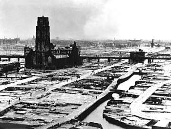
The construction of the Nieuwe Waterweg in 1863 marked the start of the growth of the Port of Rotterdam. On 14 May 1940, during the Second World War, the centre of Rotterdam was destroyed by a German bombardment. The subsequent German occupation of the Netherlands resulted in anti-Jewish measures, and many members of Dutch resistance were captured and executed on the Waalsdorpervlakte. At the same time, the Atlantikwall was constructed along the coast. After the Second World War, in 1953, the south of South Holland was heavily struck by the North Sea flood, which took the lives of 677 South Hollanders. After this, the Dutch government decided for the construction of the Delta Works, which came to an end with the completion of the Maeslantkering in 1997.
Geography
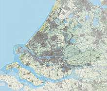
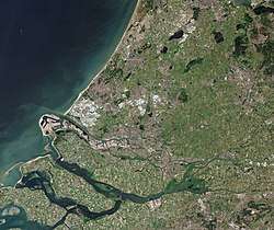
South Holland covers an area of 3,403 km2 (1,314 sq mi), of which 585 km2 (226 sq mi) is water. It borders the North Sea to the west, North Holland to the north, Utrecht and Gelderland to the east, and North Brabant and Zeeland to the south. Beside the dunes along the North Sea coast, the province is almost entirely flat and mostly consists of polders. The centre of South Holland and the area along the coast in the west are largely urban, part of the Randstad conurbation, while the east of the province is more agrarian and belongs to the Groene Hart, literally Green Heart. The south of the province is a collection of islands in the Rhine–Meuse–Scheldt delta. For census reasons, South Holland is divided into four regions: Rijnmond, South, West and East.
The Duin- en Bollenstreek is a region in the north-west of South Holland, around Katwijk, that features coastal dunes and the cultivation of flower bulbs. To the south of the region lie mostly pastures on sand soil, that form the transition to more urban area. This urban area runs along the Old Rhine, from Katwijk via Rijnsburg to Leiden and Zoeterwoude-Rijndijk. South of Leiden and north of The Hague lies an area where a landscape of dunes bordering the North Sea in the west transitions to one of peat more to the east. The easternmost tip of South Holland is part of De Biesbosch, one of the largest national parks of the Netherlands and one of the last freshwater tide areas in Europe. Other parks in South Holland, although no national parks, include Delftse Hout east of Delft,[7] Ackerdijkse Plassen, a bird reserve north of Rotterdam,[8] and Buytenpark and Westerpark near Zoetermeer.[9] The Kagerplassen are a collection of lakes north-east of Leiden, popular for boating, watersports, fishing, camping and walking.

The southern part of South Holland consists of a number of islands of the Rhine–Meuse–Scheldt delta. Although technically islands in the sense that they are surrounded by rivers, canals or other bodies of water, most of these islands are well connected to the rest of the province via bridges, tunnels and dams. The southern islands, most notably Goeree-Overflakkee (1 on the map), Tiengemeten (2), Hoeksche Waard (6) and Voorne-Putten (4/5), are largely agrarian, while more to the north, the islands are more urban, such as Dordrecht (7), IJsselmonde (9) and Rozenburg (10), while other islands, like Rozenburg (10), are mostly used for petrochemical industry. Together, these cities form the Rijnmond conurbation, centred on the city of Rotterdam. Together with Haaglanden (centred on The Hague) and Delfland (centred on Delft) in the north, and the Drechtsteden to the south-east, this conurbation in turn forms the South Wing of the Randstad conurbation, which spans across South Holland, North Holland and Utrecht.
Other regions in South Holland include Alblasserwaard, Gouwestreek ("The Gouwe Area"), Hoeksche Waard, Krimpenerwaard, Rijnland ("Rhineland"), Rijnstreek ("The Rhine Area"), Vijfheerenlanden and Westland (roughly including Hoek van Holland and the municipalities of Westland and Midden-Delfland).
Climate
Like the rest of the Netherlands, South Holland experiences a temperate oceanic climate, a Cfb-class according to the Köppen climate classification. The climate is influenced by the North Sea and the Atlantic Ocean, which results in relatively cooler summers and milder winters. Rain showers are common in the fall and winter seasons. Because of the flat surface, wind storms are also not uncommon in the winter. Although rain occurs all year long, the first six months of the year are relatively dry. Eastern winds can result in temporary continental climate conditions with relatively warm and dry summers and cold and stormy winters. The temperature varies between the 2 °C and 6 °C in the winter and 17 °C and 20 °C in the summer.
| Climate data for Rotterdam The Hague Airport | |||||||||||||
|---|---|---|---|---|---|---|---|---|---|---|---|---|---|
| Month | Jan | Feb | Mar | Apr | May | Jun | Jul | Aug | Sep | Oct | Nov | Dec | Year |
| Record high °C (°F) | 14.1 (57.4) |
16.7 (62.1) |
21.2 (70.2) |
26.7 (80.1) |
30.5 (86.9) |
32.8 (91.0) |
33.1 (91.6) |
34.9 (94.8) |
29.0 (84.2) |
24.8 (76.6) |
18.3 (64.9) |
15.1 (59.2) |
34.9 (94.8) |
| Average high °C (°F) | 6.0 (42.8) |
6.6 (43.9) |
9.9 (49.8) |
13.5 (56.3) |
17.5 (63.5) |
19.9 (67.8) |
22.2 (72.0) |
22.1 (71.8) |
18.9 (66.0) |
14.7 (58.5) |
9.9 (49.8) |
6.6 (43.9) |
14.0 (57.2) |
| Daily mean °C (°F) | 3.6 (38.5) |
3.7 (38.7) |
6.4 (43.5) |
9.1 (48.4) |
12.9 (55.2) |
15.5 (59.9) |
17.8 (64.0) |
17.6 (63.7) |
14.8 (58.6) |
11.2 (52.2) |
7.3 (45.1) |
4.2 (39.6) |
10.4 (50.7) |
| Average low °C (°F) | 0.8 (33.4) |
0.5 (32.9) |
2.6 (36.7) |
4.3 (39.7) |
7.8 (46.0) |
10.6 (51.1) |
13.1 (55.6) |
12.8 (55.0) |
10.6 (51.1) |
7.5 (45.5) |
4.2 (39.6) |
1.4 (34.5) |
6.4 (43.5) |
| Record low °C (°F) | −17.1 (1.2) |
−13.8 (7.2) |
−11.4 (11.5) |
−6.0 (21.2) |
−1.4 (29.5) |
0.5 (32.9) |
3.6 (38.5) |
4.6 (40.3) |
0.4 (32.7) |
−5.1 (22.8) |
−7.5 (18.5) |
−13.3 (8.1) |
−17.1 (1.2) |
| Average precipitation mm (inches) | 69.1 (2.72) |
57.9 (2.28) |
64.9 (2.56) |
42.6 (1.68) |
58.3 (2.30) |
65.2 (2.57) |
74.0 (2.91) |
81.0 (3.19) |
87.1 (3.43) |
90.1 (3.55) |
87.1 (3.43) |
78.3 (3.08) |
855.6 (33.69) |
| Average precipitation days (≥ 1 mm) | 12 | 10 | 12 | 9 | 9 | 10 | 10 | 10 | 12 | 12 | 13 | 13 | 131 |
| Average snowy days | 6 | 5 | 4 | 2 | 0 | 0 | 0 | 0 | 0 | 0 | 2 | 4 | 22 |
| Average relative humidity (%) | 88 | 85 | 83 | 78 | 77 | 79 | 79 | 80 | 84 | 86 | 89 | 89 | 83 |
| Mean monthly sunshine hours | 62.5 | 83.8 | 124.0 | 174.9 | 213.9 | 203.6 | 213.1 | 196.6 | 137.6 | 106.9 | 60.4 | 46.7 | 1,623.8 |
| Source 1: Royal Netherlands Meteorological Institute (1981–2010 normals, snowy days normals for 1971–2000)[10] | |||||||||||||
| Source 2: Royal Netherlands Meteorological Institute (1971–2000 extremes)[11] | |||||||||||||
Municipalities
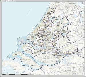
South Holland is divided into 52 municipalities.
- Leiden & Bollenstreek COROP group
- The Hague COROP group
- Delft & Westland COROP group
- East South Holland COROP group
- Rijnmond COROP group
- South West South Holland COROP group
Economy
.jpg)
The Gross domestic product (GDP) of the region was 163.8 billion € in 2018. This contributes to the gross domestic product of the Netherlands for 21.2%. GDP per capita adjusted for purchasing power was 38,700 € or 128% of the EU27 average in the same year.[12] South Holland's labour force amounts 1,661,000 people; 47.1% of the total population. The unemployment rate is 6.1% in 2013.[13]
Main sectors of economical activity in this province are among others:
- Horticulture is an important sector in South Holland. The province is home to around 2550 glasshouse companies, approximately half of the Netherlands' total.[14] Specifically the Westland is well known for its intensive horticulture. The glasshouses in this region cover an area of 2,750 hectares (10.6 sq mi),[15] making it the world's largest contiguous greenhouse area.[16]
- Flower bulb cultivation;
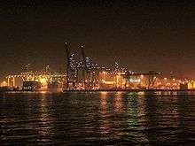
- Port of Rotterdam;
- Petrochemical industry, particularly near Rotterdam neighbourhood Pernis; (Shell's refinery there is the largest oil refinery in Europe, and one of the largest in the world);
- The service-oriented economy of The Hague, where many jobs are offered by the national government (of which the main administrative parts are settled in this town), international institutions and headquarters of several large international businesses;
- Tourism related activities (among others in historic places like Delft, and in several seaside resorts);
- Commercial fishing; main South Holland fishing places are Katwijk and Scheveningen;
- Stock breeding, of which in this province dairy industry is the main sector.
Notable residents
Two well known scientists originating from South Holland are:
- Antonie van Leeuwenhoek (1632–1723), father of microbiology and developer of the microscope
- Desiderius Erasmus, philosopher and humanist.
As far as art concerns, several famous painters originate from this province; such as:
- Rembrandt, (Leiden)
- Jan Steen, (Leiden)
- Johannes Vermeer, (Delft)
See also
- List of cities, towns and villages in South Holland
- Politics of South Holland
- The Gorzen, a nature park
References
- http://www.waarstaatjeprovincie.nl/Paginas/Ruimtelijke%20ordening/Oppervlakte.aspx
- https://opendata.cbs.nl/statline/#/CBS/nl/dataset/37230ned/table
- "CBS StatLine - Regional key figures; national accounts". statline.cbs.nl.
- XE.com average EUR/ USD ex. rate in 2014
- "Sub-national HDI - Area Database - Global Data Lab". hdi.globaldatalab.org. Retrieved 2018-09-13.
- https://opendata.cbs.nl/statline/#/CBS/nl/dataset/37230ned/table
- "Category:Delftse Hout - Wikimedia Commons". commons.wikimedia.org.
- "Ackerdijkse plassen web page in Dutch". Archived from the original on 2013-10-19. Retrieved 2013-12-04.
- Page in Dutch about Westerpark on site Zoetermeer municipality Archived 2013-12-12 at the Wayback Machine
- "Klimaattabel Rotterdam, langjarige gemiddelden, tijdvak 1981–2010" (PDF) (in Dutch). Royal Netherlands Meteorological Institute. Retrieved 10 September 2013.
- "Klimaattabel Rotterdam, langjarige extremen, tijdvak 1971–2000" (PDF) (in Dutch). Royal Netherlands Meteorological Institute. Retrieved 10 September 2013.
- "Regional GDP per capita ranged from 30% to 263% of the EU average in 2018". Eurostat.
- "Regio's in economisch perspectief 2013" (PDF) (in Dutch). 30 November 2012. Retrieved 15 April 2014.
- "Leegstand van kassen in Westland dreigt" (in Dutch). Nu.nl. 22 October 2012. Retrieved 29 April 2014.
- "De Kracht van het Westland" (PDF) (in Dutch). 2008. Archived from the original (PDF) on 2014-04-29. Retrieved 29 April 2014.
- "GLASTUINBOUW" (in Dutch). Westland.nl. 22 October 2012. Retrieved 29 April 2014.
External links
| Wikimedia Commons has media related to South Holland. |
| Wikivoyage has a travel guide for South Holland. |
