Giessenlanden
Giessenlanden (Dutch: [ˈɣisə(n)ˌlɑndə(n)] (![]()
Giessenlanden | |
|---|---|
 Castle in Schelluinen | |
 Flag  Coat of arms | |
.svg.png) Location in South Holland | |
| Coordinates: 51°53′N 4°57′E | |
| Country | Netherlands |
| Province | South Holland |
| Municipality | Molenlanden |
| Established | 1 January 1986 |
| Area | |
| • Total | 65.11 km2 (25.14 sq mi) |
| • Land | 63.57 km2 (24.54 sq mi) |
| • Water | 1.54 km2 (0.59 sq mi) |
| Elevation | −1 m (−3 ft) |
| Time zone | UTC+1 (CET) |
| • Summer (DST) | UTC+2 (CEST) |
| Postcode | 3380–3381, 4209, 4220–4225, 4240–4241 |
| Area code | 0183, 0184 |
| Website | www |
On 1 January 2019, it merged with Molenwaard to form the new municipality of Molenlanden.[3]
Topography
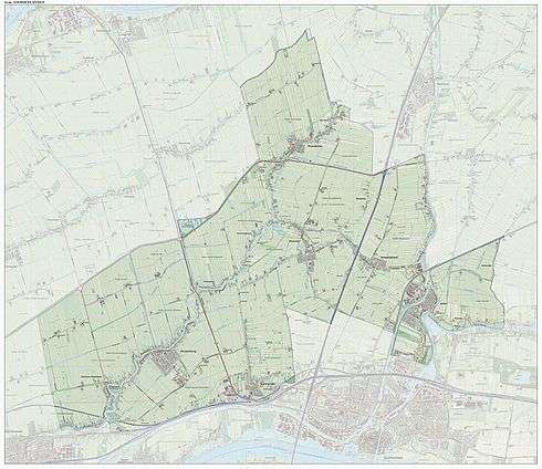
Dutch topographic map of the municipality of Giessenlanden, June 2015
Public transportation
The Arkel railway station, on the Elst–Dordrecht railway, is situated in the municipality Giessenlanden.
gollark: This is a rapIt contains the word bapLike trees have sapThere exists a word "tap"
gollark: nerðs
gollark: @everyone knows that <@341618941317349376> can live without constant pings.
gollark: I should add recommended system specs to clarify this.
gollark: That should be fine too.
References
- "Kerncijfers wijken en buurten" [Key figures for neighbourhoods]. CBS Statline (in Dutch). CBS. 2 July 2013. Retrieved 12 March 2014.
- "Postcodetool for 4223ME". Actueel Hoogtebestand Nederland (in Dutch). Het Waterschapshuis. Archived from the original on 21 September 2013. Retrieved 19 July 2013.
- "Herindeling Molenwaard-Giessenlanden". Retrieved 3 January 2019.
External links
Places adjacent to Giessenlanden | ||||||||||
|---|---|---|---|---|---|---|---|---|---|---|
| ||||||||||
This article is issued from Wikipedia. The text is licensed under Creative Commons - Attribution - Sharealike. Additional terms may apply for the media files.