Soriyankuppam
Soriyankuppam is a village[1] in Bahour Commune of Bahour taluk in the Union Territory of Puducherry, India. Soriyankuppam serves as a bypass for Puducherry - Panruti route via Savadi. It lies on southern tip of Bahour Enclave of Puducherry district.
Soriyankuppam | |
|---|---|
Village | |
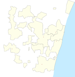 Soriyankuppam Location in Puducherry, India  Soriyankuppam Soriyankuppam (India) | |
| Coordinates: 11.787018°N 79.731045°E | |
| Country | |
| State | Puducherry |
| District | Pondicherry |
| Taluk | Bahour |
| Commune | Bahour |
| Population (2001) | |
| • Total | 36,983 |
| Languages | |
| • Official | French, Tamil, English |
| Time zone | UTC+5:30 (IST) |
| PIN | 607 402 |
| Telephone code | 0413 |
| Vehicle registration | PY-01 |
| Sex ratio | 50% ♂/♀ |
Geography
Soriyankuppam is bordered by Irandairavilagam village of Tamil nadu in the west, Kuruvinatham in the north, Parikkalpattu in the east and Pennaiyar River in the south.
Road Network
Soriyankuppam is connected to Bahour, its Commune Headquarters via Kuruvinatham road. Cuddalore-Pallinelliyanur Major District Road (MDR) passes through Soriyankuppam. Soriyankuppam is directly connected to Puducherry by Puducherry - Soriyankuppam Bus route.
Gallery
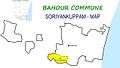 Map of Soriyankuppam Village Panchayat
 Sooriyankuppam Village Panchayat Office, Bahour Commune
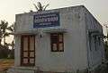 Anganvadi, Sooriyankuppam, Bahour Commune
Politics
Soriyankuppam is a part of Bahour (Union Territory Assembly constituency) which comes under Puducherry (Lok Sabha constituency)
References
- "Archived copy" (PDF). Archived from the original (PDF) on 27 September 2013. Retrieved 17 March 2013.CS1 maint: archived copy as title (link)