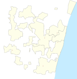
Bahour (East)
Bahour (East) is a Village in Commune in the Union Territory of Puducherry, India. It consists of few areas of Bahour and the entire part of Bahourpet.
Bahour(East) | |
|---|---|
Village | |
 Bahour(East) Location in Puducherry, India  Bahour(East) Bahour(East) (India) | |
| Coordinates: 11.806489°N 79.745378°E | |
| Country | |
| State | Puducherry |
| District | Puducherry |
| Population (2001) | |
| • Total | 36,983 |
| Languages | |
| • Official | French, Tamil, English |
| Time zone | UTC+5:30 (IST) |
| PIN | 607 402 |
| Telephone code | 0413 |
| Vehicle registration | PY-01 |
| Sex ratio | 50% ♂/♀ |
Geography
Bahour (East) is bordered by Bahour(West) in the west, Kudiyiruppupalayam in the north, Manapattu, Krishnavaram in the east and Parikkalpattu in the south.
Road Network
Kanniakoil–Bahour Road (RC-28) passes through Bahour(East). This road connects Bahour with National Highways-45A.
Gallery
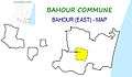 Map of Bahour(East) Village Panchayat
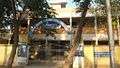 Government Primary School, Bahour Pet
gollark: There was a government program to fund fibre connectivity, but it doesn't seem to have worked well.
gollark: A lot of developed countries seem to have issues like this because the old stuff technically works and has tons of inertia and regulatory nonsense and nobody cares enough to replace it, but developing ones which didn't have big telephone networks or whatever presumably just installed fibre and did fine.
gollark: The UK isn't very good at infrastructure.
gollark: Yes, I'll just manually lay fibre to the nearest internet exchange.
gollark: Or G.fast occasionally.
References
This article is issued from Wikipedia. The text is licensed under Creative Commons - Attribution - Sharealike. Additional terms may apply for the media files.