Sokolyne
Sokolyne (Ukrainian: Соколине; Crimean Tatar: Kökköz) is a village in Bakhchysarai Raion (district) of the Autonomous Republic of Crimea, a territory recognized by a majority of countries as part of Ukraine and incorporated by Russia as the Republic of Crimea. Population: 1,251 (2014 Census).[1]
| Year | Pop. | ±% |
|---|---|---|
| 1864 | 869 | — |
| 1887 | 1,449 | +66.7% |
| 1897 | 1,687 | +16.4% |
| 1926 | 1,630 | −3.4% |
| 1939 | 1,898 | +16.4% |
| 1989 | — | |
| 2001 | 1,396 | — |
Sokolyne Соколине | |
|---|---|
Village | |
.svg.png) Sokolyne Location of Sokolyne on a map of Crimea. | |
| Coordinates: 44°33′00″N 33°57′34″E | |
| Country | Disputed |
| Republic | Crimea |
| District | Bakhchysarai Raion |
| Elevation | 281 m (922 ft) |
| Population (2014) | |
| • Total | 1,251 |
| Time zone | UTC+4 (MSK) |
| Index | 98475 |
| Area code(s) | +380-6554 |
Gallery

 Hunting Lodge of Prince Felix Yusupov in Kokkoz
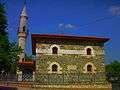
gollark: Ah, the issue is just that it needs to be saved to a file.
gollark: ... did it just not work? Annoying.
gollark: I have an improved version here: https://pastebin.com/DQHZ86YC
gollark: It's not meant to be *good*.
gollark: Also, it only runs on Linux.
References
- Russian Federal State Statistics Service (2014). "Таблица 1.3. Численность населения Крымского федерального округа, городских округов, муниципальных районов, городских и сельских поселений" [Table 1.3. Population of Crimean Federal District, Its Urban Okrugs, Municipal Districts, Urban and Rural Settlements]. Федеральное статистическое наблюдение «Перепись населения в Крымском федеральном округе». ("Population Census in Crimean Federal District" Federal Statistical Examination) (in Russian). Federal State Statistics Service. Retrieved January 4, 2016.
External links

Communities of Bakhchysarai Raion | ||
|---|---|---|
| Cities | Coat of arms of Bakhchysarai Raion | |
| Settlements |
| |
| Villages |
| |
This article is issued from Wikipedia. The text is licensed under Creative Commons - Attribution - Sharealike. Additional terms may apply for the media files.