Soalala District
Soalala is a district in western Madagascar. It is a part of Boeny Region and borders the districts of Mitsinjo in northeast, Ambato-Boeni in east, Kandreho in south and Besalampy in west. The area is 6,578 km2 (2,540 sq mi) and the population was estimated to be 27,434 in 2001.
Soalala District | |
|---|---|
District | |
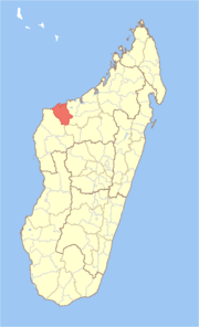 Location in Madagascar | |
| Coordinates: 16°26′S 45°23′E | |
| Country | |
| Region | Boeny |
| Area | |
| • Total | 6,578 km2 (2,540 sq mi) |
| Population (2001) | |
| • Total | 27,434 |
| • Density | 4.2/km2 (11/sq mi) |
| • Ethnicities | Sakalava |
| Time zone | UTC3 (EAT) |
The district is further divided into three communes:
The Namoroka National Park is situated in the Soalala District.
References and notes
gollark: Yes, *definitely* a "joke".
gollark: <@!160279332454006795> please check spudnet now.
gollark: <https://media.discordapp.net/attachments/738758410446569563/739587538905333810/unknown.png>
gollark: Please hold on.
gollark: ANTI LYRIC PROPAGANDA
This article is issued from Wikipedia. The text is licensed under Creative Commons - Attribution - Sharealike. Additional terms may apply for the media files.