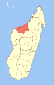
Marovoay District
Marovoay is a district in northwestern Madagascar. It is a part of Boeny Region and borders the districts of Mahajanga II in north, Boriziny and Mampikony in east, Ambato-Boeni in south and Mitsinjo in west. The area is 3,804 km2 (1,469 sq mi) and the population was estimated to be 182,742 in 2013.[1]
Marovoay District | |
|---|---|
District | |
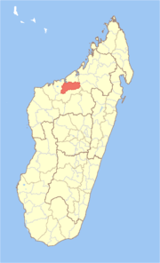 Location in Madagascar | |
| Coordinates: 16°9′S 46°37′E | |
| Country | |
| Region | Boeny |
| Area | |
| • Total | 3,804 km2 (1,469 sq mi) |
| Population (2013) | |
| • Total | 182,742 |
| • Density | 48/km2 (120/sq mi) |
| Time zone | UTC3 (EAT) |
The district is further divided into 12 communes.
References and notes
- Institut National de la Statistique, Madagascar.
gollark: But red dwarves eventually become blue dwarves or something, apparently... I think it's something with having more helium?
gollark: I mean, if you remove mass, it'll become a red dwarf, which is NOT what we want.
gollark: Hmm. This must be prevented. But how?
gollark: <:crow_of_judgement:724658449174233169>
gollark: Do you *not* have a laptop to type on? It would really save time.
This article is issued from Wikipedia. The text is licensed under Creative Commons - Attribution - Sharealike. Additional terms may apply for the media files.