Slavětín (Louny District)
Slavětín is a market town (městys) in Louny District in the Ústí nad Labem Region of the Czech Republic.
Slavětín | |
|---|---|
Městys | |
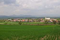 Panorama of Slavětín with the hills of České Středohoří range in the background | |
 Coat of arms | |
 Slavětín | |
| Coordinates: 50°21′2″N 13°54′27″E | |
| Country | |
| Region | Ústí nad Labem |
| District | Louny |
| Area | |
| • Total | 8.40 km2 (3.24 sq mi) |
| Elevation | 230 m (750 ft) |
| Population (2007) | |
| • Total | 443 |
| • Density | 53/km2 (140/sq mi) |
| Postal code | 439 09 to 440 01 |
| Website | http://www.slavetin.info |
The town covers an area of 8.40 square kilometres (3.24 sq mi), and has a population of 443 (as at 31 December 2007).
Slavětín lies approximately 8 kilometres (5 mi) east of Louny, 36 km (22 mi) south of Ústí nad Labem, and 47 km (29 mi) north-west of Prague.
Notable people
- Konstantin Biebl, Czech poet
- Otto Trefný, Czech doctor and politician
gollark: I could totally believe it from PHP.
gollark: They WHAT.
gollark: In uncool languages like Go, if you call a C function it suspends all goroutines being executed on that thread, which is very excellent design with no problems.
gollark: So you can EXPOSE functions.
gollark: ```lisp (let Str "The quick brown fox jumped over the lazy dog's back" (pack (mapcar '((B) (pad 2 (hex B))) (native "libcrypto.so" "MD5" '(B . 16) Str (length Str) '(NIL (16)) ) ) ) )```
This article is issued from Wikipedia. The text is licensed under Creative Commons - Attribution - Sharealike. Additional terms may apply for the media files.