Slater, Colorado
Slater is an unincorporated community and a U.S. Post Office located in both Moffat County, and Routt County, Colorado, United States. The Slater Post Office has the ZIP Code 81653.[2]
Slater, Colorado | |
|---|---|
 Location in Moffat County and part of lies within the boundary of Routt County and the state of Colorado  Slater, Colorado (the United States) | |
| Coordinates: 40°55′37″N 107°28′57″W | |
| Country | |
| State | |
| County | Moffat County, Routt County[1] |
| Elevation | 7,753 ft (2,363 m) |
| Time zone | UTC-7 (MST) |
| • Summer (DST) | UTC-6 (MDT) |
| ZIP code[2] | 81653 |
| Area code(s) | 970 |
| GNIS feature ID | 1952147 |
Slater is unusual in that, while it lies within Colorado, the main highway which services the town is Wyoming Highway 70, which dips south of the state line into Colorado for approximately 0.9 miles through Slater before turning north back into Wyoming. The highway through Slater is maintained by the Wyoming Department of Transportation.
Geography
Slater is located at 40°55′37″N 107°28′57″W (40.927003,-107.482510).
gollark: ABR runs gollariosity detection neural nets over all messages.
gollark: Our gollariomemes are highly advanced.
gollark: We've been able to assemble Turing machines out of social constructs actually.
gollark: Words don't actually exist.
gollark: We should fix this by using a superior, formally specified, parseable language.
References
- "US Board on Geographic Names". United States Geological Survey. 2007-10-25. Retrieved 2008-01-31.
- "ZIP Code Lookup" (JavaScript/HTML). United States Postal Service. January 3, 2007. Retrieved January 3, 2007.
Municipalities and communities of Moffat County, Colorado, United States | ||
|---|---|---|
| City | 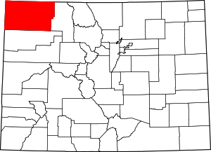 Map of Colorado highlighting Moffat County | |
| Town | ||
| CDP | ||
| Unincorporated communities |
| |
| Ghost town | ||
This article is issued from Wikipedia. The text is licensed under Creative Commons - Attribution - Sharealike. Additional terms may apply for the media files.