Sierra de Algairén
Sierra de Algairén is a mountain range in Aragon, Spain, located between the comarcas of Campo de Cariñena and Comunidad de Calatayud. The ridge's highest summit is Pico de Valdemadera (1,276 m).[1]
| Sierra de Algairén | |
|---|---|
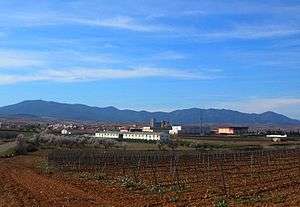 The Sierra de Algairén behind Cariñena | |
| Highest point | |
| Peak | Pico de Valdemadera |
| Elevation | 1,276 m (4,186 ft) |
| Listing | List of mountains in Aragon |
| Coordinates | 41°21′23″N 01°22′35″W |
| Geography | |
 Sierra de Algairén Location in Spain | |
| Location | Campo de Cariñena & Comunidad de Calatayud (Aragon) |
| Parent range | Iberian System |
| Geology | |
| Orogeny | Alpine orogeny |
| Age of rock | Paleozoic |
| Type of rock | Sandstone and slate |
| Climbing | |
| First ascent | Unknown |
| Easiest route | Drive from Almonacid de la Sierra, Cosuenda or Tobed |
Description
The Algairén Mountains are covered with forest made up pine, Carrasca (Quercus ilex), cork oak, and also maple trees.[2] They are a Special Protection Area for birds.
These mountains are part of the central area of the Iberian System and the summits are often covered with snow in the winter.
gollark: Hello, "new" "player".
gollark: 🌵
gollark: Just... keep potatOS?
gollark: It'll be an apricot in the next version.
gollark: I worry that I may have been slightly insane while writing the hedgehog bit.
References
External links

- Tourism in Zaragoza - Sierra de Algairén
- Sierra de Algairén y Pico del Águila
- Pico Valdemadera (1276 m) - Las sierras cercanas
This article is issued from Wikipedia. The text is licensed under Creative Commons - Attribution - Sharealike. Additional terms may apply for the media files.