Shellmound, Mississippi
Shellmound is an unincorporated community located in Leflore County, Mississippi, United States, located approximately 6 miles (9.7 km) north of Greenwood and approximately 6 miles (9.7 km) southeast of Schlater near U.S. Highway 49E.
Shellmound, Mississippi | |
|---|---|
 | |
 Shellmound  Shellmound | |
| Coordinates: 33°36′23″N 90°16′47″W | |
| Country | United States |
| State | Mississippi |
| County | Leflore |
| Elevation | 135 ft (41 m) |
| Time zone | UTC-6 (Central (CST)) |
| • Summer (DST) | UTC-5 (CDT) |
| ZIP code | 38930 |
| Area code(s) | 662 |
| GNIS feature ID | 692223[1] |
It is part of the Greenwood, Mississippi micropolitan area.
Guitar Slim Mississippi Blues Trail marker
Music
Shellmound is home to one of Leflore County's seven Mississippi Blues Trail markers (at Racetrack Plantation)[2]
Gallery
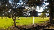
 O.F. Bledsoe Building located in the community
gollark: It would be ... simultaneously quite neat and worrying ... if we got AI stuff which could solve a lot of tasks at human level or better while not working with remotely human-like mental patterns.
gollark: Yes. But they're still annoying.
gollark: And have "rights" and stuff.
gollark: Babies are annoying.
gollark: I think the main issue is just that "life" is extremely complicated. Also not that well-defined.
References
- U.S. Geological Survey Geographic Names Information System: Shellmound, Mississippi
- "County Blues Markers". Greenwood Commonwealth. 29 December 2011.
Municipalities and communities of Leflore County, Mississippi, United States | ||
|---|---|---|
| Cities |  Map of Mississippi highlighting Leflore County | |
| Towns | ||
| CDP | ||
| Unincorporated communities | ||
| Ghost town | ||
| Footnotes | ‡This populated place also has portions in an adjacent county or counties | |
This article is issued from Wikipedia. The text is licensed under Creative Commons - Attribution - Sharealike. Additional terms may apply for the media files.