Shaykhontohur
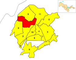
Shaykhontohur (also spelled Shayxontohur) is one of 11 districts (tuman) of Tashkent, the capital of Uzbekistan.
Shaykhontohur Shayxontohur | |
|---|---|
 | |
| Country | |
| Municipality | Tashkent |
| Established | 1981 |
| Area | |
| • Total | 27.2 km2 (10.5 sq mi) |
| Population (2009)[1] | |
| • Total | 285,800 |
| • Density | 11,000/km2 (27,000/sq mi) |
Overview
It is a north-western district, established in 1981 with the name of Oktober,[2] referring to the October Revolution, part of Russian Revolution of 1917. It is the most densely populated tuman.
Shaykhontohur, borders with the districts of Uchtepa, Chilanzar, Yakkasaray, Yunusabad and Olmazar. It borders also with Tashkent Province and is close to the Uzbek frontier with South Kazakhstan Province, in Kazakhstan.
gollark: It's not the developers' fault that GMail is stupid.
gollark: Someone can sign up for an account using a differently dotted version of your email, and it'll seem like one which is actually directed to you.
gollark: Or, er, not-really-phishing.
gollark: Because phishing attacks.
gollark: It;s a really stupidisoiasufi feature.
References
- (in Russian) Statistics of the subdivisions of Tashkent
- Sadikov, A C; Akramob Z. M., Bazarbaev, A., Mirzlaev T.M., Adilov S. R., Baimukhamedov X. N., et al. (in Russian) (72x112). Geographical Atlas of Tashkent (Ташкент Географический Атлас) (2 ed.). Moscow. p. 64.
This article is issued from Wikipedia. The text is licensed under Creative Commons - Attribution - Sharealike. Additional terms may apply for the media files.