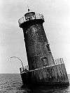
Sharkfin Shoal Light
The Sharkfin Shoal Light was a screw-pile lighthouse located at the mouth of the Nanticoke River in Chesapeake Bay, US.
  | |

| |
| Location | Southwest of Clay Island at the mouth of the Nanticoke River |
|---|---|
| Coordinates | 38.2020°N 75.9868°W |
| Year first lit | 1892 |
| Deactivated | 1964 |
| Foundation | screw-pile |
| Construction | cast-iron/wood |
| Tower shape | hexagonal house |
| Tower height | 44 feet (13 m) |
| Focal height | 13.5 metre |
| Original lens | fourth-order Fresnel lens |
| Characteristic | white 6 sec flash with red sector |
History
This light was constructed in 1892 to replace the Clay Island Light to the northeast. In 1964, the house was dismantled and a skeleton tower light placed on the foundation.
gollark: I mean, isn't much of the "information" content of stuff... relative to other things?
gollark: The "is information" bit is weird.
gollark: Basically by definition, stuff which goes in cannot come out.
gollark: Black holes can't do that.
gollark: You can hardly go around operating on "grapheme clusters" or something all the time. Codepoints are basically good enough.
References
- "Historic Light Station Information and Photography: Maryland" (PDF). United States Coast Guard Historian's Office.
- Sharkfin Shoal Light, from the Chesapeake Chapter of the United States Lighthouse Society
- de Gast, Robert (1973). The Lighthouses of the Chesapeake. Johns Hopkins University Press. p. 165.
External links
- Rowlett, Russ. "Lighthouses of the United States: Maryland". The Lighthouse Directory. University of North Carolina at Chapel Hill.
This article is issued from Wikipedia. The text is licensed under Creative Commons - Attribution - Sharealike. Additional terms may apply for the media files.
