Serra d'Esparreguera
Serra de d'Esparreguera or Serra Esparreguera[1] (Spanish: Sierra de Esparraguera,[2] although the spellings Sierra de Espaneguera or Sierra Espaneguera are common in many maps[3]) is an over 17 km (11 mi) long mountain range in the Alt Maestrat comarca, Valencian Community, Spain.
| Serra d'Esparreguera | |
|---|---|
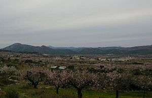 Eastern end of the Serra d'Esparreguera, near Albocàsser; the Penyagolosa can be discerned in the distance | |
| Highest point | |
| Elevation | 1,087 m (3,566 ft) |
| Listing | List of mountains in the Valencian Community |
| Coordinates | 40°18′31″N 0°5′21″W |
| Geography | |
 Serra d'Esparreguera Spain | |
| Location | Alt Maestrat, Valencian Community |
| Parent range | Iberian System, Eastern end |
| Geology | |
| Mountain type | Karstic |
| Climbing | |
| Easiest route | From Culla or from La Torre d'En Besora |
Geography
This mountain chain rises abruptly from a plain and looks quite impressive from certain angles. It extends in a roughly SW-NE direction between Atzeneta del Maestrat and Albocàsser. Its highest point is 1087 m high Esparreguera; another important summit is Morral Blanc (1060 m). These mountains are frequently covered in snow in the winter.
gollark: That's what you would say if you wanted to avoid COMPARTMENTAL SLATS 2.0.
gollark: ```python>>> ctypes.cast(ctypes.c_int64(1103), ctypes.c_char_p)Traceback (most recent call last): File "<stdin>", line 1, in <module> File "/usr/lib/python3.8/ctypes/__init__.py", line 507, in cast return _cast(obj, obj, typ)ctypes.ArgumentError: argument 1: <class 'TypeError'>: wrong type```It should have let me do this.
gollark: Give me a spec™ and I might**** implement it for* you.
gollark: `libc.printf(ctypes.c_char_p(b"apioform entities"))`Apparently this works.
gollark: I just want it to blindly reinterpret `7` as a `ctypes.c_void_p`, this is ridiculous.
See also
- Culla
- Mountains of the Valencian Community
References
- Vicenç M. Rosselló i Verger, Toponímia, geografia i cartografia
- Sierra de Esparraguera ca. 829 m
- Mendikat Espaneguera
External links
This article is issued from Wikipedia. The text is licensed under Creative Commons - Attribution - Sharealike. Additional terms may apply for the media files.