Schwechat (river)
| Schwechat | |
|---|---|
 | |
 | |
| Location | |
| Country | Austria |
| State | Lower Austria |
| Towns | Alland, Baden, Schwechat |
| Physical characteristics | |
| Source | |
| • location | Schöpfl, Vienna Woods |
| Mouth | Danube |
• location | near Schwechat |
• coordinates | 48.1375°N 16.5603°E |
| Length | 52.0 km (32.3 mi)[1] |
| Basin features | |
| Tributaries | |
| • left | Sattelbach, Mödlingbach, Petersbach, Liesing |
| • right | Triesting, Kalter Gang |
| Progression | Danube→ Black Sea |
The Schwechat is a river in Lower Austria.
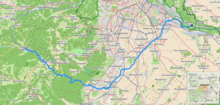
River course
The source is near the Schöpfl (893 m) in the Vienna Woods. The source streams are the Riesenbach, Lammeraubach, Agsbach, Hainbach and the Großkrottenbach which all confluence at Klausen-Leopoldsdorf forming the Schwechat. It flows through the small town Alland, through the Helenental to Baden and through the Vienna Basin to Schwechat, where the river ends in the Danube.
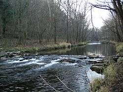
Helenental
The Helenental is the Schwechat's valley from Mayerling to Baden, named for the parish church of St Helena (Pfarrkirche St Helena) about 2 miles (3 km) from the town center of Baden.[2] Originally gothic, it's since been replaced by a baroque structure.
BeethovenwegHelenentalUrtelstein.jpg)
Helenental, Urtelstein
gollark: That's not really possible.
gollark: I fed skynet-cli into itself in a loop, if anyone was wondering why skynet just underwent very heavy load.
gollark: What;s that from?
gollark: The curbs could be slabs and the middle nice fast concrete.
gollark: You could put slabs round the edges instead.
References
Citations
- Niederösterreich Atlas (Lower Austria)
- Baedeker (2000), p. 107.
Bibliography
- Baedeker's Austria, Baedeker's Guides, translated from the German by James Hogarth for AA Publishing, 2000.
External links

This article is issued from Wikipedia. The text is licensed under Creative Commons - Attribution - Sharealike. Additional terms may apply for the media files.