Schwarzenbach am Wald
Schwarzenbach am Wald is a town in the district of Hof, in Bavaria, Germany. It is situated 21 km west of Hof, and 23 km northeast of Kulmbach.
Schwarzenbach a.Wald | |
|---|---|
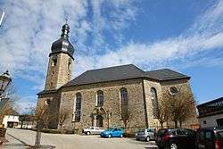 Lutheran Church of Jesus | |
 Coat of arms | |
Location of Schwarzenbach a.Wald within Hof district 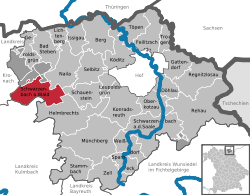 | |
 Schwarzenbach a.Wald  Schwarzenbach a.Wald | |
| Coordinates: 50°17′0″N 11°37′15″E | |
| Country | Germany |
| State | Bavaria |
| Admin. region | Oberfranken |
| District | Hof |
| Subdivisions | 39 Ortsteile |
| Government | |
| • Mayor | Rainer Feulner (CSU) |
| Area | |
| • Total | 36.50 km2 (14.09 sq mi) |
| Elevation | 686 m (2,251 ft) |
| Population (2018-12-31)[1] | |
| • Total | 4,395 |
| • Density | 120/km2 (310/sq mi) |
| Time zone | CET/CEST (UTC+1/+2) |
| Postal codes | 95131 |
| Dialling codes | 09289 |
| Vehicle registration | HO |
| Website | www.schwarzenbach-wald.de |
Geographic
Geographical Situation
Schwarzenbach am Wald is situated in a natural environment at the bottom of the Döbraberg in the natural park Frankenwald
City Structure
|
|
|
gollark: Isn't this harder to iterate through?
gollark: I feel like it's much less hassle to just assume they/them, as it's gender-neutral, for everyone on the internet.
gollark: https://medium.com/@rakeshkrish/ssh-bitcoin-wallet-demystifying-another-crypto-scam-afee7ad37f35
gollark: <@398682548395311124> It's a known honeypot thing.
gollark: I have it hooked to a keyboard shortcut.
References
- "Fortschreibung des Bevölkerungsstandes". Bayerisches Landesamt für Statistik und Datenverarbeitung (in German). July 2019.
Towns and municipalities in Hof (district) | ||
|---|---|---|
| Coat of Arms of Hof district | |
| Authority control |
|
|---|
This article is issued from Wikipedia. The text is licensed under Creative Commons - Attribution - Sharealike. Additional terms may apply for the media files.