Sautens
Sautens is a municipality in the Imst district located 9 kilometres (6 mi) southeast of Imst on the lower course of the Ötztaler Ache. The village is located to catch the sun but is protected from the wind, which makes for an especially mild climate. The main source of income is agriculture. Fruit is especially important with a good part of the harvest used to make Schnapps.
Sautens | |
|---|---|
 | |
 Coat of arms | |
 Location in the district | |
 Sautens Location within Austria | |
| Coordinates: 47°12′30″N 10°51′55″E | |
| Country | Austria |
| State | Tyrol |
| District | Imst |
| Government | |
| • Mayor | Manfred Köll |
| Area | |
| • Total | 11.61 km2 (4.48 sq mi) |
| Elevation | 812 m (2,664 ft) |
| Population (2018-01-01)[2] | |
| • Total | 1,601 |
| • Density | 140/km2 (360/sq mi) |
| Time zone | UTC+1 (CET) |
| • Summer (DST) | UTC+2 (CEST) |
| Postal code | 6432 |
| Area code | 05252 |
| Vehicle registration | IM |
| Website | www.sautens.tirol.gv.at |
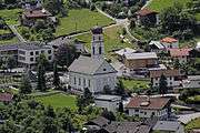
Sautens Neue Pfarrkirche
The name of the village appears to originate from Roman times. Sautens was once connected with Oetz but became its own community in 1836. Recently the village has experienced increasing tourism.
Population
| Year | Pop. | ±% |
|---|---|---|
| 1869 | 692 | — |
| 1880 | 657 | −5.1% |
| 1890 | 609 | −7.3% |
| 1900 | 559 | −8.2% |
| 1910 | 543 | −2.9% |
| 1923 | 604 | +11.2% |
| 1934 | 650 | +7.6% |
| 1939 | 654 | +0.6% |
| 1951 | 761 | +16.4% |
| 1961 | 792 | +4.1% |
| 1971 | 927 | +17.0% |
| 1981 | 1,081 | +16.6% |
| 1991 | 1,203 | +11.3% |
| 2001 | 1,280 | +6.4% |
| 2011 | 1,417 | +10.7% |
gollark: <@282594912682115074> Try putting up your own trade and asking for 2 CB Golds. It is inevitable.
gollark: I can just \@everyone, silly.
gollark: Hey, that worked.
gollark: <@!137959364320296961>
gollark: Stuff like, say, no pagination, or a broken market, are undoubtedly serious and Broken.
References
- "Dauersiedlungsraum der Gemeinden Politischen Bezirke und Bundesländer - Gebietsstand 1.1.2018". Statistics Austria. Retrieved 10 March 2019.
- "Einwohnerzahl 1.1.2018 nach Gemeinden mit Status, Gebietsstand 1.1.2018". Statistics Austria. Retrieved 9 March 2019.
External links
| Wikimedia Commons has media related to Sautens. |
| Authority control |
|
|---|
This article is issued from Wikipedia. The text is licensed under Creative Commons - Attribution - Sharealike. Additional terms may apply for the media files.