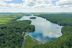
Saugatuck Reservoir
The Saugatuck Reservoir is a reservoir in Fairfield County, Connecticut, United States, that straddles the border between the towns of Redding, Weston, and Easton[2]. Its completion is marked by the creation of the Samuel P. Senior dam[3] of the Saugatuck River in January 1942[4], and provides water to several of the nearby towns. The reservoir is surrounded by the Centennial Watershed State Forest[5] and a small section of the Trout Brook Valley State Park Reserve on the southeast end of the reservoir. The Saugatuck Reservoir utilizes an uncontrolled spillway adjacent to the Samuel P. Senior dam that effectively limits the maximum water level. There is also a concrete levee positioned on the southeastern side of the reservoir that prevents water from flooding Trout Brook Valley.
| Saugatuck Reservoir | |
|---|---|
 | |
| Location | Fairfield County, Connecticut, United States |
| Coordinates | 41.265°N 73.365°W |
| Type | reservoir |
| Primary inflows | Saugatuck River |
| Primary outflows | Saugatuck River |
| Catchment area | 35 square miles (91 km2) |
| Basin countries | United States |
| Surface area | 827 acres (3.35 km2)[1] |
| Average depth | average 45 feet (14 m) |
| Max. depth | 110 feet (34 m) |
| Water volume | 37,215 acre feet (45,904,000 m3) |
| Shore length1 | 13 miles (21 km) |
| Surface elevation | 279 ft (85 m) |
| 1 Shore length is not a well-defined measure. | |
Bridgeport Hydraulic Company Holdings (now owned by Aquarion) flooded the Saugatuck River Valley after 1938[6][7], removing the villages of Hull and Valley Forge[8][9] to create the Saugatuck Reservoir.[10]
Aquarion Water Co., owner of the reservoir and dam, allows tailrace fishing in one area at the Weston end of the reservoir, where it has constructed a handicapped-access area. However, anglers must obtain a permit from Aquarion before fishing in the Saugatuck.[11]
The Saugatuck is the largest of the eight reservoirs that make up Aquarion’s greater Bridgeport water system. It holds about 12 billion US gallons (45,000,000 m3) of water.[12]
The following fish species may be found within the Saugatuck Reservoir[13]:
- American eel
- Bluegill (Sunfish)
- Brook trout
- Brown trout
- Bullhead catfish
- Chain pickerel
- Crappie
- Largemouth bass
- Pumpkinseed (Sunfish)
- Rainbow trout
- Rock bass
- Smallmouth bass
- Walleye
- White perch
- Yellow perch
References
- Saugatuck Reservoir, Connecticut, USA - Lakelubbers
- Lomuscio, James (2005). Village of the Dammed. University Press of New England. p. 1.
- National Program for Inspection of Non-Federal Dams. Samuel P. Senior Reservoir Dam (CT 00108), and Popps Mountain Dike (CT 00022), Connecticut Western Coastal Area, Weston, Connecticut. Phase I Inspection Report.
- "Aquarion Company | Encyclopedia.com". www.encyclopedia.com. Retrieved 2020-07-08.
- "Centennial Watershed State Forest". CT.GOV. July 18, 2016.
- FIGHT RESERVOIR PROJECT; Residents Offer to Finance a Suit by Weston, Conn., November 27, 1937, Page 9, 144 words, THE NEW YORK TIMES.
- SUE TO PREVENT DAM; Saugatuck Valley Residents Seek Injunction and $250,000, February 3, 1938, Page 10, 133 words, THE NEW YORK TIMES.
- Valley Forge Forever Gone Archived 2009-11-03 at the Wayback Machine, By Marcia Miner, The Aspetuck Land Trust
- The rise and fall of Valley Forge, Published: 12:00 a.m., Sunday, March 26, 2006, Robert Miller, THE NEWS-TIMES
- Village of the Damned: the fight for open space and the flooding of a Connecticut town. By James Lomuscio, ISBN 1-58465-477-5 ISBN 978-1584654773
- Fishing by permit, Recreation - Aquarion
- Redding Saugatuck Reservoir Where has all the water gone?, Nov 29, 2007, TheReddingPilot.com
- "Fishing Saugatuck Reservoir In CT - Map, Fish Species, Lake Info". www.aa-fishing.com. Retrieved 2020-07-08.
External links
- Saugatuck Reservoir Trail, Centennial Watershed, State Forest, Easton, Newtown, Redding, Weston - DEP