Sarkandaugava
Sarkandaugava | |
|---|---|
Neighborhood of Riga | |
 | |
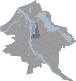 Location in Riga | |
| Country | |
| City | Riga |
| District | Northern District, Riga |
| Area | |
| • Total | 7,596 km2 (2,933 sq mi) |
| Population (2010) | |
| • Total | 19 189 |
| Time zone | UTC+2 (EET) |
| • Summer (DST) | UTC+3 (EEST) |
Origins of the name
The name of the neighbourhood derives from that of the Sarkandaugava ('Red Daugava'; German: Rote Düna), a minor arm of the Daugava that formerly separated Pētersala from the mainland. As Riga developed and expanded, more and more of the Sarkandaugava was filled in, but it still appeared on maps from the late 1930s. All that remains of the Sarkandaugava today is a small, unnamed bay next to the bridge from the Tvaika street area over to Kundziņsala.
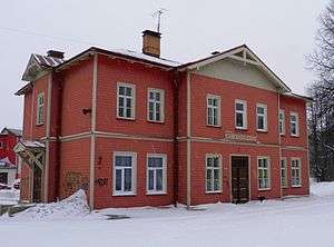
Sarkandaugava railway station
gollark: I also asked for "SCP-055 in containment", but it probably doesn't know what that is.
gollark: It seems okay at landscapes. This is "mountain waterfall at dusk" with the top 8 of 32 images using the CLIP ranking option.
gollark: It's obviously a spambot.
gollark: That sounds like something which would improve* and not worsen** the situation.
gollark: You could do it both ways I guess, perhaps with a switch.
External links
- History of Sarkandaugava (in Russian)
- The home page about Sarkandaugava - www.citariga.lv
- Kadinsky, Sergey "Sarkandaugava, Riga" Hidden Waters Blog November 14, 2016
This article is issued from Wikipedia. The text is licensed under Creative Commons - Attribution - Sharealike. Additional terms may apply for the media files.