Sarangani, Davao Occidental
Sarangani, officially the Municipality of Sarangani (Cebuano: Lungsod sa Sarangani; Tagalog: Bayan ng Sarangani), is a 4th class municipality in the province of Davao Occidental, Philippines. According to the 2015 census, it has a population of 24,039 people.[3]
Sarangani | |
|---|---|
| Municipality of Sarangani | |
Nickname(s):
| |
| Motto(s): Sarangani Bayan Natin, Sarangani Paraiso Natin! | |
 Map of Davao Occidental with Sarangani highlighted | |
OpenStreetMap 
| |
.svg.png) Sarangani Location within the Philippines | |
| Coordinates: 5°24′N 125°28′E | |
| Country | |
| Region | Davao Region (Region XI) |
| Province | Davao Occidental |
| District | Lone District |
| Founded | 1980 |
| Barangays | 12 (see Barangays) |
| Government | |
| • Type | Sangguniang Bayan |
| • Mayor | Virginia T. Cawa |
| • Vice Mayor | Jerry T. Cawa Jr. |
| • Congressman | Lorna B. Bandigan |
| • Electorate | 15,130 voters (2019) |
| Area | |
| • Total | 97.72 km2 (37.73 sq mi) |
| Population (2015 census)[3] | |
| • Total | 24,039 |
| • Density | 250/km2 (640/sq mi) |
| • Households | 5,632 |
| Economy | |
| • Income class | 4th municipal income class |
| • Poverty incidence | 59.53% (2015)[4] |
| • Revenue (₱) | 70,082,321.62 (2016) |
| Time zone | UTC+8 (PST) |
| ZIP code | 8015 |
| PSGC | |
| IDD : area code | +63 (0)82 |
| Climate type | tropical rainforest climate |
| Native languages | Davawenyo Cebuano Sarangani language Sangirese Tagalog |
| Website | www |
The municipality consists of 2 major islands (the eponymous Sarangani Island and Balut Island) and 1 minor islet (Olanivan Island), collectively called as the Sarangani Islands, located just south of Mindanao island in the Celebes Sea. It is the municipality of the Philippines bordering Indonesia.
Barangays
Sarangani is politically subdivided into 12 barangays.
- Batuganding
- Konel
- Lipol
- Mabila (Poblacion)
- Tinina
- Gomtago
- Tagen
- Tucal
Sarangani Island
- Patuco (Sarangani Norte) (includes Olanivan islet)
- Laker (Sarangani Sur)
- Camahual
- Camalig
Demographics
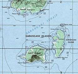
Map of the Sarangani islands
| Year | Pop. | ±% p.a. |
|---|---|---|
| 1980 | 11,960 | — |
| 1990 | 15,003 | +2.29% |
| 1995 | 16,648 | +1.97% |
| 2000 | 18,391 | +2.16% |
| 2007 | 20,394 | +1.44% |
| 2010 | 23,290 | +4.95% |
| 2015 | 24,039 | +0.60% |
| Source: Philippine Statistics Authority[3][5][6][7] | ||
Climate
| Climate data for Sarangani, Davao Occidental | |||||||||||||
|---|---|---|---|---|---|---|---|---|---|---|---|---|---|
| Month | Jan | Feb | Mar | Apr | May | Jun | Jul | Aug | Sep | Oct | Nov | Dec | Year |
| Average high °C (°F) | 31 (88) |
31 (88) |
31 (88) |
31 (88) |
30 (86) |
29 (84) |
29 (84) |
29 (84) |
30 (86) |
30 (86) |
30 (86) |
31 (88) |
30 (86) |
| Average low °C (°F) | 23 (73) |
23 (73) |
23 (73) |
24 (75) |
24 (75) |
24 (75) |
24 (75) |
24 (75) |
24 (75) |
24 (75) |
24 (75) |
23 (73) |
24 (74) |
| Average precipitation mm (inches) | 88 (3.5) |
65 (2.6) |
92 (3.6) |
109 (4.3) |
197 (7.8) |
271 (10.7) |
256 (10.1) |
241 (9.5) |
192 (7.6) |
206 (8.1) |
192 (7.6) |
121 (4.8) |
2,030 (80.2) |
| Average rainy days | 14.3 | 12.2 | 15.1 | 18.1 | 26.0 | 27.3 | 26.1 | 25.0 | 23.4 | 26.1 | 25.4 | 20.5 | 259.5 |
| Source: Meteoblue [8] | |||||||||||||
Local government
Municipal officials 2013-2016:
- Mayor: Virginia Cawa
- Vice Mayor: Jerry Cawa
- Councilors:
- Alfredo Lora
- Sergio Tablingon
- Adelan de Arce
- Jamere Ismael
- Lorencio Angin
- Windy Grace Gomez
- Jovanie Amierol
- Arturo Olarte, Jr.
gollark: 1. ignore exam, spend years learning highly advanced physics and engineering2. build time machine3. learn stuff for exams4. go back in time to now, replace past self, hope nobody notices, do exam
gollark: Someone was spamming and asked to be banned for incomprehensible reasons.
gollark: CEASE.
gollark: Not really. I mean, somewhat.
gollark: That's a very overly specific use. Besides that, death kills three people a second, particularly bad dictators and whatnot waaaay less than that.
References
- "Municipality". Quezon City, Philippines: Department of the Interior and Local Government. Retrieved 31 May 2013.
- "Province: Davao Occidental". PSGC Interactive. Quezon City, Philippines: Philippine Statistics Authority. Retrieved 12 November 2016.
- Census of Population (2015). "Region XI (Davao Region)". Total Population by Province, City, Municipality and Barangay. PSA. Retrieved 20 June 2016.
- "PSA releases the 2015 Municipal and City Level Poverty Estimates". Quezon City, Philippines. Retrieved 12 October 2019.
- Census of Population and Housing (2010). "Region XI (Davao Region)". Total Population by Province, City, Municipality and Barangay. NSO. Retrieved 29 June 2016.
- Censuses of Population (1903–2007). "Region XI (Davao Region)". Table 1. Population Enumerated in Various Censuses by Province/Highly Urbanized City: 1903 to 2007. NSO.
- "Province of Davao del Sur". Municipality Population Data. Local Water Utilities Administration Research Division. Retrieved 17 December 2016.
- "Sarangani: Average Temperatures and Rainfall". Meteoblue. Retrieved 28 January 2020.
External links
- Sarangani Profile at PhilAtlas.com
- Philippine Standard Geographic Code
- Philippine Census Information
- Local Governance Performance Management System
Places adjacent to Sarangani, Davao Occidental | ||||||||||
|---|---|---|---|---|---|---|---|---|---|---|
| ||||||||||
Malita (capital) | |
| Municipalities | |
| Authority control |
|
|---|
This article is issued from Wikipedia. The text is licensed under Creative Commons - Attribution - Sharealike. Additional terms may apply for the media files.