Sangamon Township, Piatt County, Illinois
Sangamon Township is a township in Piatt County, Illinois, USA. As of the 2010 census, its population was 2,357 and it contained 929 housing units.[2]
Sangamon Township | |
|---|---|
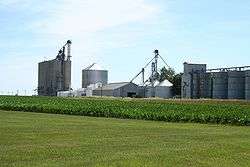 Grain elevators in the unincorporated hamlet of Galesville, in section 32 of Sangamon township. | |
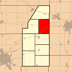 Location in Piatt County | |
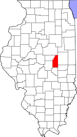 Piatt County's location in Illinois | |
| Coordinates: 40°06′40″N 88°30′52″W | |
| Country | United States |
| State | Illinois |
| County | Piatt |
| Established | November 8, 1859 |
| Area | |
| • Total | 47.25 sq mi (122.4 km2) |
| • Land | 47.18 sq mi (122.2 km2) |
| • Water | 0.06 sq mi (0.2 km2) 0.13% |
| Elevation | 673 ft (205 m) |
| Population (2010) | |
| • Estimate (2016)[1] | 2,351 |
| • Density | 50/sq mi (20/km2) |
| Time zone | UTC-6 (CST) |
| • Summer (DST) | UTC-5 (CDT) |
| FIPS code | 17-147-67587 |
Geography
According to the 2010 census, the township has a total area of 47.25 square miles (122.4 km2), of which 47.18 square miles (122.2 km2) (or 99.85%) is land and 0.06 square miles (0.16 km2) (or 0.13%) is water.[2] Lakes in this township include Buck Pond (historical). The stream of Madden Creek runs through this township.
Cities and towns
- Monticello (northeast three-quarters)
Unincorporated towns
Extinct towns
- Centerville
Adjacent townships
- Blue Ridge Township (north)
- Mahomet Township, Champaign County (northeast)
- Scott Township, Champaign County (east)
- Colfax Township, Champaign County (southeast)
- Monticello Township (south)
- Goose Creek Township (west)
Cemeteries
The township contains nine cemeteries: Argo, Boyer, Bucks Pond, Camp Creek, Hughes, Ingram, Mackey, Madden and Mallory.
Major highways


Airports and landing strips
- Clapper Airport
Demographics
| Historical population | |||
|---|---|---|---|
| Census | Pop. | %± | |
| Est. 2016 | 2,351 | [1] | |
| U.S. Decennial Census[3] | |||
gollark: Two weeks? Why?
gollark: Shadow Walkers are probably my favourite Halloween ones, though I've not seen many.
gollark: If you pick that one, I'll buy the aeon, though I can't offer much.
gollark: I'd offer too.
gollark: I've seen fewer aeons than golds, though probably mostly because I don't frequent forest/alpine much.
References
- "Population and Housing Unit Estimates". Retrieved June 9, 2017.
- "Population, Housing Units, Area, and Density: 2010 - County -- County Subdivision and Place -- 2010 Census Summary File 1". United States Census. Archived from the original on 2020-02-12. Retrieved 2013-05-28.
- "Census of Population and Housing". Census.gov. Retrieved June 4, 2016.
External links
Municipalities and communities of Piatt County, Illinois, United States | ||
|---|---|---|
| City | Map of Illinois highlighting Piatt County | |
| Villages | ||
| Townships | ||
| CDPs | ||
| Other unincorporated communities | ||
| Footnotes | ‡This populated place also has portions in an adjacent county or counties | |
This article is issued from Wikipedia. The text is licensed under Creative Commons - Attribution - Sharealike. Additional terms may apply for the media files.