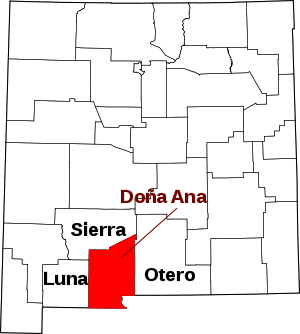
San Miguel, New Mexico
San Miguel is a census-designated place in Doña Ana County, New Mexico, United States. Its population was 1,153 as of the 2010 census.[1] San Miguel has a post office with ZIP code 88058.[3] The community is located at the junction of New Mexico State Road 28 and New Mexico State Road 192.
San Miguel, New Mexico | |
|---|---|
Census-designated place | |
 San Miguel | |
| Coordinates: 32°09′19″N 106°44′06″W | |
| Country | United States |
| State | New Mexico |
| County | Doña Ana |
| Area | |
| • Total | 2.288 sq mi (5.93 km2) |
| • Land | 2.288 sq mi (5.93 km2) |
| • Water | 0 sq mi (0 km2) |
| Elevation | 3,822 ft (1,165 m) |
| Population | |
| • Total | 1,153 |
| • Density | 500/sq mi (190/km2) |
| Time zone | UTC-7 (Mountain (MST)) |
| • Summer (DST) | UTC-6 (MDT) |
| ZIP code | 88058 |
| Area code(s) | 575 |
| GNIS feature ID | 920696[2] |
Geography
San Miguel is located at 32.153459°N 106.726850°W. According to the U.S. Census Bureau, the community has an area of 2.288 square miles (5.93 km2), all of it land.[1]
Education
The Gadsden Independent School District operates public schools, including North Valley Elementary School. The designated High School(s) for this area would either be Gadsden High School or Alta Vista Early College High SChool.[4]
gollark: Anyway, thing is, the electoral college is not actually a very good mechanism for giving rural areas more power, that just works as a pretext for it.
gollark: But not split proportionally *by area* or something.
gollark: It might make more sense split proportionally and not winner-takes-all, which I'm pretty sure is the case now.
gollark: That would be rebalancing it even more ridiculously arbitrarily.
gollark: What, not statewise?
References
- "2010 Census Gazetteer Files - Places: New Mexico". U.S. Census Bureau. Archived from the original on July 14, 2014. Retrieved August 21, 2014.
- "San Miguel". Geographic Names Information System. United States Geological Survey.
- https://tools.usps.com/go/ZipLookupResultsAction!input.action?resultMode=0&companyName=&address1=&address2=&city=San+Miguel&state=NM&urbanCode=&postalCode=&zip=
- "Elementary schools Archived 2015-09-24 at the Wayback Machine." Gadsden Independent School District. Retrieved on August 19, 2015.
This article is issued from Wikipedia. The text is licensed under Creative Commons - Attribution - Sharealike. Additional terms may apply for the media files.
