San Benito, California
San Benito is an unincorporated community in San Benito County, California, United States. San Benito is 18 miles (29 km) southeast of Paicines. The community had a post office from 1869 to 1968.[2]
San Benito, California | |
|---|---|
 San Benito, California | |
| Coordinates: 36°30′35″N 121°04′55″W | |
| Country | United States |
| State | California |
| County | San Benito |
| Elevation | 1,345 ft (410 m) |
| Time zone | UTC-8 (Pacific (PST)) |
| • Summer (DST) | UTC-7 (PDT) |
| Area code(s) | 831 |
| GNIS feature ID | 1659575[1] |
Climate
This region experiences warm (but not hot) and dry summers, with no average monthly temperatures above 71.6 °F. According to the Köppen Climate Classification system, San Benito has a warm-summer Mediterranean climate, abbreviated "Csb" on climate maps.[3]
gollark: How competent of them.
gollark: Great. This was definitely a correct and not incorrect inference.
gollark: Assumed gaiety.
gollark: Fascinating.
gollark: Do you think I'm more likely to answer questions if you say them twice?
References
- U.S. Geological Survey Geographic Names Information System: San Benito, California
- Durham, David L. (2000). Durham's Place Names of California's Central Coast. Quill Driver Books. p. 991. ISBN 1-884995-29-2.
- Climate Summary for San Benito, California
Municipalities and communities of San Benito County, California, United States | ||
|---|---|---|
| Cities | 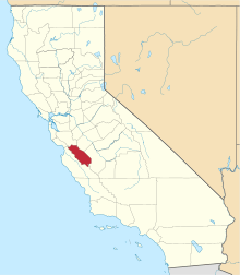 San Benito County map | |
| CDPs | ||
| Unincorporated communities | ||
| Ghost town | ||
| Footnotes | ‡This populated place also has portions in an adjacent county or counties | |
This article is issued from Wikipedia. The text is licensed under Creative Commons - Attribution - Sharealike. Additional terms may apply for the media files.