Salt Creek Township, Holmes County, Ohio
Salt Creek Township is one of the fourteen townships of Holmes County, Ohio, United States. As of the 2010 census the population was 4,252,[3] up from 3,778 at the 2000 census.
Salt Creek Township, Holmes County, Ohio | |
|---|---|
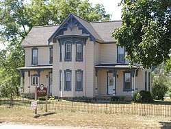 The Joseph Armstrong Farmhouse, a historic site in the township | |
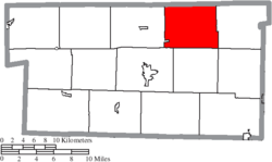 Location of Salt Creek Township in Holmes County | |
| Coordinates: 40°38′12″N 81°49′37″W | |
| Country | United States |
| State | Ohio |
| County | Holmes |
| Area | |
| • Total | 29.9 sq mi (77.4 km2) |
| • Land | 29.8 sq mi (77.3 km2) |
| • Water | 0.04 sq mi (0.1 km2) |
| Elevation | 1,099 ft (335 m) |
| Population (2010) | |
| • Total | 4,252 |
| • Density | 142/sq mi (55.0/km2) |
| Time zone | UTC-5 (Eastern (EST)) |
| • Summer (DST) | UTC-4 (EDT) |
| ZIP code | 44660 |
| Area code(s) | 330 |
| FIPS code | 39-70156[2] |
| GNIS feature ID | 1086338[1] |
Geography
Located in the northern part of the county, it borders the following townships:
- Salt Creek Township, Wayne County - north
- Paint Township, Wayne County - northeast corner
- Paint Township - east
- Walnut Creek Township - southeast corner
- Berlin Township - south
- Hardy Township - southwest
- Prairie Township - west
- Franklin Township, Wayne County - northwest corner
No municipalities are located in Salt Creek Township, although the unincorporated community of Mount Hope lies in the eastern part of the township.
Name and history
It is one of five Salt Creek Townships statewide.[4]
Government
The township is governed by a three-member board of trustees, who are elected in November of odd-numbered years to a four-year term beginning on the following January 1. Two are elected in the year after the presidential election and one is elected in the year before it. There is also an elected township fiscal officer,[5] who serves a four-year term beginning on April 1 of the year after the election, which is held in November of the year before the presidential election. Vacancies in the fiscal officership or on the board of trustees are filled by the remaining trustees.
References
- "US Board on Geographic Names". United States Geological Survey. 2007-10-25. Retrieved 2008-01-31.
- "U.S. Census website". United States Census Bureau. Retrieved 2008-01-31.
- "Geographic Identifiers: 2010 Census Summary File 1 (G001): Salt Creek township, Holmes County, Ohio". American Factfinder. U.S. Census Bureau. Archived from the original on February 13, 2020. Retrieved January 10, 2018.
- "Detailed map of Ohio" (PDF). United States Census Bureau. 2000. Retrieved 2007-02-16.
- §503.24, §505.01, and §507.01 of the Ohio Revised Code. Accessed 4/30/2009.
External links
Municipalities and communities of Holmes County, Ohio, United States | ||
|---|---|---|
| Villages | 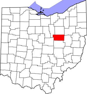 Map of Ohio highlighting Holmes County | |
| Townships | ||
| CDPs | ||
| Unincorporated communities | ||
| Footnotes | ‡This populated place also has portions in an adjacent county or counties | |