Saint Stephens meridian
The Saint Stephens meridian, in longitude 88° 02′ west from Greenwich, begins at the initial point (Ellicott's Corner), on the base line, in latitude 31° north, passes through Saint Stephens, Alabama, extends south to Mobile Bay and north to latitude 33° 06′ 20″, and governs the surveys in the southern district of Alabama, and in Pearl River district lying east of the river and south of the Choctaw Baseline, in latitude 31° 52′ 40″ north, in the state of Mississippi.
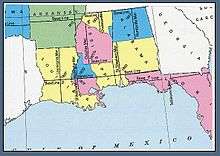
U.S. Bureau of Land Management map showing the principal meridians in Louisiana, Mississippi, and Alabama
Sources
- Raymond, William Galt (1914). Plane Surveying for Use in the Classroom and Field (via Internet Archive). New York: American Book Company.
gollark: Doesn't `explorer.exe` run the entire desktop UI or am I mixing it up with other stuff?
gollark: That sounds... problem.
gollark: Um.
gollark: Seems wasteful.
gollark: With null-terminated strings, getting the length takes `O(n)` time, and it is possible to mess up very easily.
External links
- "Cadastral Survey [St. Stephens Meridian]". U.S. Bureau of Land Management. Retrieved 2012-10-06.
- "Principal Meridians and Base Lines". U.S. Bureau of Land Management. Archived from the original on 2012-10-18. Retrieved 2012-10-06.
- "St. Stephens Principal Meridian, Mt Vernon, AL". Principal Meridian Project. Retrieved 2012-10-06.
- "St. Stephens Meridian". The Center for Land Use Interpretation. Retrieved 2012-10-06.
This article is issued from Wikipedia. The text is licensed under Creative Commons - Attribution - Sharealike. Additional terms may apply for the media files.