Saint-Laurent-des-Arbres
Saint-Laurent-des-Arbres is a commune in the Gard department in southern France.
Saint-Laurent-des-Arbres | |
|---|---|
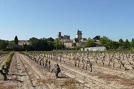 A general view of Saint-Laurent-des-Arbres | |
 Coat of arms | |
Location of Saint-Laurent-des-Arbres 
| |
 Saint-Laurent-des-Arbres  Saint-Laurent-des-Arbres | |
| Coordinates: 44°03′19″N 4°42′02″E | |
| Country | France |
| Region | Occitanie |
| Department | Gard |
| Arrondissement | Nîmes |
| Canton | Roquemaure |
| Intercommunality | Côte du Rhône Gardoise |
| Government | |
| • Mayor (2008–2014) | Michel Anastasy |
| Area 1 | 16.35 km2 (6.31 sq mi) |
| Population (2017-01-01)[1] | 3,072 |
| • Density | 190/km2 (490/sq mi) |
| Time zone | UTC+01:00 (CET) |
| • Summer (DST) | UTC+02:00 (CEST) |
| INSEE/Postal code | 30278 /30126 |
| Elevation | 39–261 m (128–856 ft) (avg. 60 m or 200 ft) |
| 1 French Land Register data, which excludes lakes, ponds, glaciers > 1 km2 (0.386 sq mi or 247 acres) and river estuaries. | |
Population
| Year | Pop. | ±% |
|---|---|---|
| 1936 | 515 | — |
| 1946 | 521 | +1.2% |
| 1954 | 701 | +34.5% |
| 1962 | 900 | +28.4% |
| 1968 | 1,847 | +105.2% |
| 1975 | 2,056 | +11.3% |
| 1982 | 1,403 | −31.8% |
| 1990 | 1,683 | +20.0% |
| 1999 | 1,743 | +3.6% |
| 2009 | 2,400 | +37.7% |
gollark: It's good for some low level stuff, but for regular application code good type and memory safety is very good.
gollark: It is very unsafe.
gollark: Or, well, C bad for most applications.
gollark: C bad.
gollark: But getting more efficient *eventually* is good, no?
References
- "Populations légales 2017". INSEE. Retrieved 6 January 2020.
Further reading
- Corvisier, Christian (2000). "Saint-Laurent-des-Arbres. Eglise fortifiée, château et tours". Congrès archéologique de France - Monuments du Gard, 157éme session 1999 (in French). Paris: Société française d'archéologie. pp. 311–337. OCLC 48728034.
External links
| Wikimedia Commons has media related to Saint-Laurent-des-Arbres. |
This article is issued from Wikipedia. The text is licensed under Creative Commons - Attribution - Sharealike. Additional terms may apply for the media files.