Saint-Jacques, Quebec
Saint-Jacques is a municipality in the Lanaudière region of Quebec, Canada, part of the Montcalm Regional County Municipality.
Saint-Jacques | |
|---|---|
Municipality | |
.jpg) | |
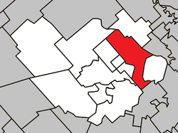 Location within Montcalm RCM | |
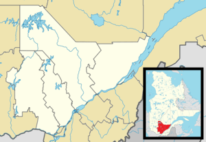 Saint-Jacques Location in central Quebec | |
| Coordinates: 45°57′N 73°34′W[1] | |
| Country | |
| Province | |
| Region | Lanaudière |
| RCM | Montcalm |
| Constituted | May 20, 1998 |
| Government | |
| • Mayor | Pierre Beaulieu |
| • Federal riding | Montcalm |
| • Prov. riding | Joliette |
| Area | |
| • Total | 67.20 km2 (25.95 sq mi) |
| • Land | 67.34 km2 (26.00 sq mi) |
| There is an apparent contradiction between two authoritative sources | |
| Population (2011)[3] | |
| • Total | 4,021 |
| • Density | 59.7/km2 (155/sq mi) |
| • Pop (2006–11) | |
| Time zone | UTC−5 (EST) |
| • Summer (DST) | UTC−4 (EDT) |
| Postal code(s) | J0K 2R0 |
| Area code(s) | 450 and 579 |
| Highways[4] | |
| Website | www |
Saint-Jacques was founded in 1774 by Acadian settlers from Boston after the Great Upheaval of 1755.
Demographics
Population trend:[5]
- Population in 2011: 4021 (2006 to 2011 population change: 8.5%)
- Population in 2006: 3706
- Population in 2001: 3692
- Population total in 1996: 3815
- Saint-Jacques Village: 2261
- Saint-Jacques Parish: 1554
- Population in 1991:
- Saint-Jacques Village: 2251
- Saint-Jacques Parish: 1542
Private dwellings occupied by usual residents: 1636 (total dwellings: 1698)
Mother tongue:
- English as first language: 0.5%
- French as first language: 98.8%
- English and French as first language: 0.4%
- Other as first language: 0.3%
Education
Commission scolaire des Samares operates francophone public schools:
The Sir Wilfrid Laurier School Board operates anglophone public schools, including:
- Joliette Elementary School in Saint-Charles-Borromée[8]
- Joliette High School in Joliette[9]
gollark: Well, this is bizarre, it's only slow if I access it in the browser and not through curl.
gollark: Caddy.
gollark: It's weirdly high-latency for some reason, but it's up.
gollark: Hey, that did fix it, neat!
gollark: Minecraft is just terribly programmed.
References
- Reference number 338834 of the Commission de toponymie du Québec (in French)
- Geographic code 63013 in the official Répertoire des municipalités (in French)
- Statistics Canada 2011 Census - Saint-Jacques census profile
- Official Transport Quebec Road Map
- Statistics Canada: 1996, 2001, 2006, 2011 census
- "de Grand-Pré." Commission scolaire des Samares. Retrieved on September 23, 2017.
- "Saint-Louis-de-France." Commission scolaire des Samares. Retrieved on September 23, 2017.
- "JOLIETTE ELEMENTARY ZONE." Sir Wilfrid Laurier School Board. Retrieved on September 17, 2017.
- "Joliette High School Zone Sec 1-5." Sir Wilfrid Laurier School Board. Retrieved on September 5, 2017.
External links

Places adjacent to Saint-Jacques, Quebec | ||||||||||
|---|---|---|---|---|---|---|---|---|---|---|
| ||||||||||
| Cities/towns | |
|---|---|
| Municipalities | |
| Parishes | |
| |
| Authority control |
|
|---|
This article is issued from Wikipedia. The text is licensed under Creative Commons - Attribution - Sharealike. Additional terms may apply for the media files.