Saint-Ignace-de-Loyola, Quebec
Saint-Ignace-de-Loyola is a municipality in the Lanaudière region of Quebec, Canada, part of the D'Autray Regional County Municipality. Its territory is located on 33 of the Sorel Islands in the Saint Lawrence River where it flows into Lac Saint-Pierre, the largest of which are île Madame, île aux Ours, and La Grande Île.[1]
Saint-Ignace-de-Loyola | |
|---|---|
Municipality | |
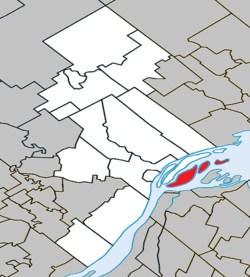 Location within D'Autray RCM. | |
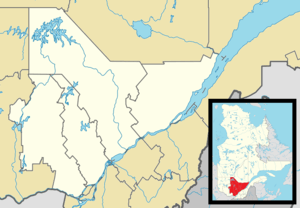 Saint-Ignace-de-Loyola Location in central Quebec. | |
| Coordinates: 46°04′N 73°08′W[1] | |
| Country | |
| Province | |
| Region | Lanaudière |
| RCM | D'Autray |
| Settled | 1669 |
| Constituted | February 11, 1897 |
| Named for | Ignatius of Loyola[1] |
| Government | |
| • Mayor | Jean-Luc Barthe |
| • Federal riding | Berthier—Maskinongé |
| • Prov. riding | Berthier |
| Area | |
| • Total | 72.50 km2 (27.99 sq mi) |
| • Land | 36.16 km2 (13.96 sq mi) |
| Population (2011)[3] | |
| • Total | 2,086 |
| • Density | 57.7/km2 (149/sq mi) |
| • Pop 2006-2011 | |
| • Dwellings | 945 |
| Time zone | UTC−5 (EST) |
| • Summer (DST) | UTC−4 (EDT) |
| Postal code(s) | J0K 2P0 |
| Area code(s) | 450 and 579 |
| Highways | |
| Website | www.stignace deloyola.qc.ca |
History
In 1895, the Parish of Saint-Ignace-de-Loyola was formed, and named in honour of the founder of the Jesuits, Ignatius López de Loyola (1491-1556). In 1896, its post office opened and a year later, the parish municipality was established by separating from La Visitation-de-l'Île-Dupas.[1]
On October 31, 2012, it changed status from a parish municipality to municipality.[1]
Demographics
Population trend:[4]
- Population in 2011: 2086 (2006 to 2011 population change: 8.4%)
- Population in 2006: 1925
- Population in 2001: 1880
- Population in 1996: 1883
- Population in 1991: 1827
Private dwellings occupied by usual residents: 885 (total dwellings: 945)
Mother tongue:
- English as first language: 0%
- French as first language: 97.7%
- English and French as first language: 0%
- Other as first language: 2.3%
Education
Commission scolaire des Samares operates francophone public schools, including:
- École de l'Île Saint-Ignace - It temporarily closed in 2016[5]
The Sir Wilfrid Laurier School Board operates anglophone public schools, including:
- Joliette Elementary School in Saint-Charles-Borromée[6]
- Joliette High School in Joliette[7]
See also
References
- Reference number 416631 of the Commission de toponymie du Québec (in French)
- Geographic code 52045 in the official Répertoire des municipalités (in French)
- Statistics Canada 2011 Census - Saint-Ignace-de-Loyola census profile
- Statistics Canada: 1996, 2001, 2006, 2011 census
- "L'école primaire de Saint-Ignace fermée temporairement". L'Action d'Autray. 2016-08-26. Retrieved 2017-09-18.
- "JOLIETTE ELEMENTARY ZONE." Sir Wilfrid Laurier School Board. Retrieved on September 17, 2017.
- "Joliette High School Zone Sec 1-5." Sir Wilfrid Laurier School Board. Retrieved on September 5, 2017.
External links
Adjacent Municipal Subdivisions | ||||||||||
|---|---|---|---|---|---|---|---|---|---|---|
| ||||||||||
| Cities & Towns | |
|---|---|
| Municipalities |
|
| Parishes | |
| |
| Authority control |
|
|---|