Saint-Guy, Quebec
Saint-Guy is a municipality in the Bas-Saint-Laurent region of Quebec, Canada.
Saint-Guy | |
|---|---|
Municipality | |
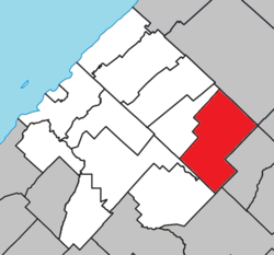 Location within Les Basques RCM | |
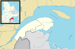 Saint-Guy Location in eastern Quebec | |
| Coordinates: 48°02′N 68°47′W[1] | |
| Country | |
| Province | |
| Region | Bas-Saint-Laurent |
| RCM | Les Basques |
| Constituted | January 1, 1958 |
| Government | |
| • Mayor | Roger Rioux |
| • Federal riding | Rimouski-Neigette—Témiscouata —Les Basques |
| • Prov. riding | Rivière-du-Loup-Témiscouata |
| Area | |
| • Total | 143.10 km2 (55.25 sq mi) |
| • Land | 139.05 km2 (53.69 sq mi) |
| Population (2011)[3] | |
| • Total | 91 |
| • Density | 0.7/km2 (2/sq mi) |
| • Pop 2006-2011 | |
| • Dwellings | 72 |
| Time zone | UTC−5 (EST) |
| • Summer (DST) | UTC−4 (EDT) |
| Postal code(s) | G0K 1W0 |
| Area code(s) | 418 and 581 |
| Highways | |
Demographics
Population
| Canada census – Saint-Guy, Quebec community profile | |||
|---|---|---|---|
| 2011 | 2006 | ||
| Population: | 91 (+2.2% from 2006) | 89 (-16.0% from 2001) | |
| Land area: | 139.05 km2 (53.69 sq mi) | 139.05 km2 (53.69 sq mi) | |
| Population density: | 0.7/km2 (1.8/sq mi) | 0.6/km2 (1.6/sq mi) | |
| Median age: | 54.5 (M: 55.0, F: 54.2) | 57.2 (M: 56.5, F: 58.2) | |
| Total private dwellings: | 72 | 65 | |
| Median household income: | $.N/A | $.N/A | |
| Notes: Income data for this area has been suppressed for data quality or confidentiality reasons. – References: 2011[4] 2006[5] earlier[6] | |||
| Year | Pop. | ±% |
|---|---|---|
| 1991 | 157 | — |
| 1996 | 108 | −31.2% |
| 2001 | 106 | −1.9% |
| 2006 | 89 | −16.0% |
| 2011 | 91 | +2.2% |
Language
| Canada Census Mother Tongue - Saint-Guy, Quebec[7] | ||||||||||||||||||
|---|---|---|---|---|---|---|---|---|---|---|---|---|---|---|---|---|---|---|
| Census | Total | French |
English |
French & English |
Other | |||||||||||||
| Year | Responses | Count | Trend | Pop % | Count | Trend | Pop % | Count | Trend | Pop % | Count | Trend | Pop % | |||||
2011 |
95 |
90 | 94.74% | 0 | 0.00% | 5 | 5.26% | 0 | 0.00% | |||||||||
2006 |
80 |
80 | 100.00% | 0 | 0.00% | 0 | 0.00% | 0 | 0.00% | |||||||||
2001 |
95 |
95 | 100.00% | 0 | 0.00% | 0 | 0.00% | 0 | 0.00% | |||||||||
1996 |
95 |
95 | n/a | 100.00% | 0 | n/a | 0.00% | 0 | n/a | 0.00% | 0 | n/a | 0.00% | |||||
gollark: Just.... use SSH?
gollark: And if you've written the JSON database thing in the way everyone does it, it is opening the file, writing whatever array is in memory to that file, and closing it.
gollark: They create a temporary file, write their buffer to that, and then move the temporary file over the original, so that if they get interrupted in the middle of writing there's less chance of data loss.
gollark: Nope. No good text editor actually works like that.
gollark: I'm inferring.
See also
References
- Reference number 56693 of the Commission de toponymie du Québec (in French)
- Geographic code 11020 in the official Répertoire des municipalités (in French)
- "(Code 2411020) Census Profile". 2011 census. Statistics Canada. 2012.
- "2011 Community Profiles". 2011 Canadian Census. Statistics Canada. July 5, 2013. Retrieved 2014-03-10.
- "2006 Community Profiles". 2006 Canadian Census. Statistics Canada. March 30, 2011. Retrieved 2014-03-10.
- "2001 Community Profiles". 2001 Canadian Census. Statistics Canada. February 17, 2012.
- Statistics Canada: 1996, 2001, 2006, 2011 census
Adjacent Municipal Subdivisions | ||||||||||
|---|---|---|---|---|---|---|---|---|---|---|
| ||||||||||
| Cities & Towns | |
|---|---|
| Municipalities |
|
| Parishes | |
| Unorganized territories | |
| |
This article is issued from Wikipedia. The text is licensed under Creative Commons - Attribution - Sharealike. Additional terms may apply for the media files.