Saint-Avit, Drôme
Saint-Avit is a commune in the Drôme department in southeastern France.
Saint-Avit | |
|---|---|
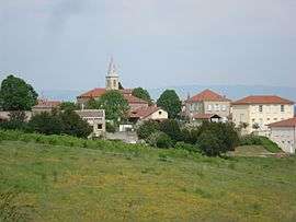 A general view of Saint-Avit | |
Location of Saint-Avit 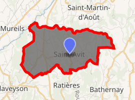
| |
 Saint-Avit  Saint-Avit | |
| Coordinates: 45°11′51″N 4°58′14″E | |
| Country | France |
| Region | Auvergne-Rhône-Alpes |
| Department | Drôme |
| Arrondissement | Valence |
| Canton | Drôme des collines |
| Intercommunality | Galaure |
| Government | |
| • Mayor (2008–2014) | Gérard Robert |
| Area 1 | 8.94 km2 (3.45 sq mi) |
| Population (2017-01-01)[1] | 306 |
| • Density | 34/km2 (89/sq mi) |
| Time zone | UTC+01:00 (CET) |
| • Summer (DST) | UTC+02:00 (CEST) |
| INSEE/Postal code | 26293 /26330 |
| Elevation | 227–443 m (745–1,453 ft) (avg. 348 m or 1,142 ft) |
| 1 French Land Register data, which excludes lakes, ponds, glaciers > 1 km2 (0.386 sq mi or 247 acres) and river estuaries. | |
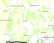
Map commune de Saint-Avit.
Saint-Avit wss detached from the municipality of Ratières on November 15, 1869 and is located 17 km east of Saint-Vallier (capital of the canton) and 10 km north of Saint-Donat-sur-l'Herbasse.
The surrounding communities are Ratières, Saint-Martin-d'Août, Bathernay, Châteauneuf-de-Galaure, Mureils and Claveyson.
Population
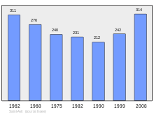
population of Saint-Avit
| Year | Pop. | ±% |
|---|---|---|
| 1911 | 419 | — |
| 1962 | 241 | −42.5% |
| 1968 | 276 | +14.5% |
| 1975 | 240 | −13.0% |
| 1982 | 231 | −3.7% |
| 1990 | 212 | −8.2% |
| 1999 | 242 | +14.2% |
| 2008 | 314 | +29.8% |
gollark: If you just clone my body, it won't actually contain bees.
gollark: Without necessarily being sure of them.
gollark: It's where mathematicians think things in their hive mind.
gollark: But the exact contents of lunch are culturally defined.
gollark: ddg! No free lunch theoren
See also
References
- "Populations légales 2017". INSEE. Retrieved 6 January 2020.
| Wikimedia Commons has media related to Saint-Avit (Drôme). |
| Authority control |
|
|---|
This article is issued from Wikipedia. The text is licensed under Creative Commons - Attribution - Sharealike. Additional terms may apply for the media files.