Saint-Alexandre-de-Kamouraska, Quebec
Saint-Alexandre-de-Kamouraska is a municipality in the Canadian province of Quebec, located in the Kamouraska Regional County Municipality.
Saint-Alexandre-de-Kamouraska | |
|---|---|
Municipality | |
 | |
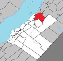 Location within Kamouraska RCM | |
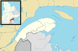 Saint-Alexandre-de-Kamouraska Location in eastern Quebec | |
| Coordinates: 47°40′54″N 69°37′30″W[1] | |
| Country | |
| Province | |
| Region | Bas-Saint-Laurent |
| RCM | Kamouraska |
| Constituted | July 1, 1855 |
| Government | |
| • Mayor | Victor Morin |
| • Federal riding | Montmagny—L'Islet—Kamouraska—Rivière-du-Loup |
| • Prov. riding | Côte-du-Sud |
| Area | |
| • Total | 116.50 km2 (44.98 sq mi) |
| • Land | 111.49 km2 (43.05 sq mi) |
| Population (2011)[3] | |
| • Total | 2,050 |
| • Density | 18.4/km2 (48/sq mi) |
| • Pop 2006-2011 | |
| • Dwellings | 870 |
| Time zone | UTC−5 (EST) |
| • Summer (DST) | UTC−4 (EDT) |
| Postal code(s) | G0L 2G0 |
| Area code(s) | 418 and 581 |
| Highways | |
| Website | www |
Before July 5, 1997, it was known simply as Saint-Alexandre.
Geography
Lakes and rivers
The following waterways pass through or are situated within the municipality's boundaries:[1]
- Lac Morin (47°37′23″N 69°32′08″W) – located along the municipality's southern border.
- Le Petit Lac (47°40′10″N 69°33′41″W)
- Petite rivière Noire (47°41′38″N 69°32′33″W)
- Rivière Carrier (47°40′11″N 69°30′42″W)
- Rivière Fourchue (47°41′19″N 69°32′31″W)
gollark: Is this just a mockup or does it actually work?
gollark: How does "attack" work?
gollark: I like it!
gollark: Observation by camera is fine, right?
gollark: 08:14, it's close ish.
See also
References
- Reference number 333323 of the Commission de toponymie du Québec (in French)
- Geographic code 14035 in the official Répertoire des municipalités (in French)
- "(Code 2414035) Census Profile". 2011 census. Statistics Canada. 2012.
External links

Adjacent Municipal Subdivisions | ||||||||||
|---|---|---|---|---|---|---|---|---|---|---|
| ||||||||||
| Cities & Towns | |
|---|---|
| Municipalities |
|
| Parishes |
|
| Unorganized territories | |
| |
| Authority control |
|
|---|
This article is issued from Wikipedia. The text is licensed under Creative Commons - Attribution - Sharealike. Additional terms may apply for the media files.