Saint-Édouard, Quebec
Saint-Édouard is a municipality in the Jardins de Napierville Regional County Municipality in Quebec, Canada, situated in the Montérégie administrative region. The population as of the Canada 2011 Census was 1,312.
- Not to be confused with Saint-Édouard-de-Fabre, Quebec
Saint-Édouard | |
|---|---|
Municipality | |
 | |
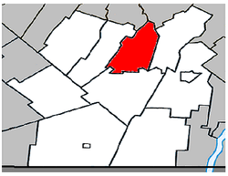 Location within Les Jardins-de-Napierville RCM. | |
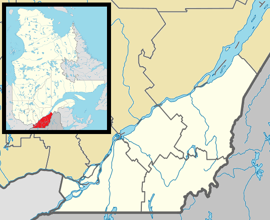 Saint-Édouard Location in southern Quebec. | |
| Coordinates: 45°14′N 73°31′W[1] | |
| Country | |
| Province | |
| Region | Montérégie |
| RCM | Les Jardins-de-Napierville |
| Constituted | July 1, 1855 |
| Government | |
| • Mayor | Michel Raymond |
| • Federal riding | Beauharnois—Salaberry |
| • Prov. riding | Huntingdon |
| Area | |
| • Total | 52.70 km2 (20.35 sq mi) |
| • Land | 52.93 km2 (20.44 sq mi) |
| There is an apparent contradiction between two authoritative sources | |
| Population (2011)[4] | |
| • Total | 1,312 |
| • Density | 24.8/km2 (64/sq mi) |
| • Pop 2006-2011 | |
| • Dwellings | 536 |
| Time zone | UTC−5 (EST) |
| • Summer (DST) | UTC−4 (EDT) |
| Postal code(s) | J0L 1Y0 |
| Area code(s) | 450 and 579 |
| Highways | |
Demographics
Population
| Canada census – Saint-Édouard, Quebec community profile | |||
|---|---|---|---|
| 2011 | 2006 | ||
| Population: | 1,312 (+8.3% from 2006) | 1,212 (+1.4% from 2001) | |
| Land area: | 52.93 km2 (20.44 sq mi) | 52.93 km2 (20.44 sq mi) | |
| Population density: | 24.8/km2 (64/sq mi) | 22.9/km2 (59/sq mi) | |
| Median age: | 39.4 (M: 39.4, F: 39.3) | 40.1 (M: 40.3, F: 39.8) | |
| Total private dwellings: | 536 | 494 | |
| Median household income: | $52,596 | $48,275 | |
| References: 2011[4] 2006[5] earlier[6] | |||
|
|
|
Language
| Canada Census Mother Tongue - Saint-Édouard, Quebec[7] | ||||||||||||||||||
|---|---|---|---|---|---|---|---|---|---|---|---|---|---|---|---|---|---|---|
| Census | Total | French |
English |
French & English |
Other | |||||||||||||
| Year | Responses | Count | Trend | Pop % | Count | Trend | Pop % | Count | Trend | Pop % | Count | Trend | Pop % | |||||
2011 |
1,315 |
1,255 | 95.44% | 20 | 1.52% | 5 | 0.38% | 35 | 2.66% | |||||||||
2006 |
1,215 |
1,175 | 96.71% | 15 | 1.23% | 0 | 0.00% | 25 | 2.06% | |||||||||
2001 |
1,205 |
1,195 | 99.17% | 10 | 0.83% | 0 | 0.00% | 0 | 0.00% | |||||||||
1996 |
1,245 |
1,200 | n/a | 96.39% | 10 | n/a | 0.80% | 0 | n/a | 0.00% | 35 | n/a | 2.81% | |||||
gollark: "Dedicated server" basically just means it's on a dedicated machine.
gollark: Not really.
gollark: BUT those things would incur a bunch of cost - either financial or time - and I don't need high uptime enough to pay that.
gollark: As an example, osmarks.tk isn't up all the time. This is probably because it runs off my home internet connection and such, and partly because I do server migrations in ways which leave services down a bit. If I actually *needed* more than the current ~99% (okay I'm wildly guessing) uptime, there are many ways I could improve it.
gollark: You *want* 24/7 uptime, but trying to squeeze out increasingly high uptime means increasingly high costs.
See also
References
- Reference number 56138 of the Commission de toponymie du Québec (in French)
- Ministère des Affaires municipales, des Régions et de l'Occupation du territoire: Saint-Édouard
- Riding history for Beauharnois—Salaberry, Quebec from the Library of Parliament
- "2011 Community Profiles". 2011 Canadian Census. Statistics Canada. July 5, 2013. Retrieved 2014-04-09.
- "2006 Community Profiles". 2006 Canadian Census. Statistics Canada. March 30, 2011. Retrieved 2014-04-09.
- "2001 Community Profiles". 2001 Canadian Census. Statistics Canada. February 17, 2012.
- Statistics Canada: 1996, 2001, 2006, 2011 census
Adjacent Municipal Subdivisions | |
|---|---|
| Cities | |
|---|---|
| Municipalities | |
| Parishes | |
| Townships | |
| Villages | |
| |
This article is issued from Wikipedia. The text is licensed under Creative Commons - Attribution - Sharealike. Additional terms may apply for the media files.