Napierville
Napierville is a municipality in the Jardins de Napierville Regional County Municipality in Quebec, Canada, situated in the Montérégie administrative region. The population as of the 2016 Canadian Census was 3,899. It is the location of the seat of the Jardins de Napierville Regional County Municipality. It is surrounded by the municipality of Saint-Cyprien-de-Napierville.
Napierville | |
|---|---|
Municipality | |
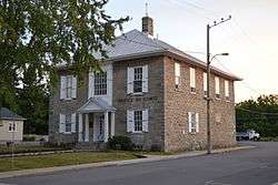 Palais de justice, Napierville | |
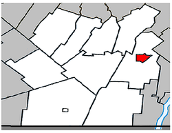 Location within Les Jardins-de-Napierville RCM. | |
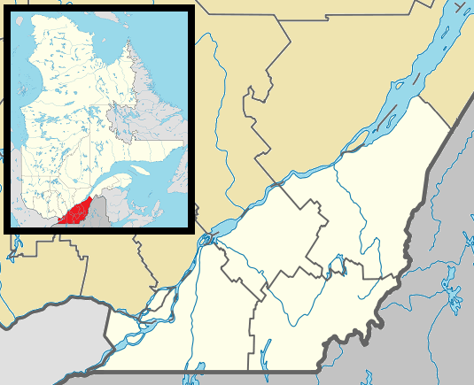 Napierville Location in southern Quebec  Napierville Napierville (Canada) | |
| Coordinates: 45°11′N 73°24′W[1] | |
| Country | Canada |
| Province | Quebec |
| Region | Montérégie |
| RCM | Les Jardins-de-Napierville |
| Constituted | January 1, 1873 |
| Government | |
| • Mayor | Alain Fredette |
| • Federal riding | Châteauguay—Lacolle |
| • Prov. riding | Huntingdon |
| Area | |
| • Total | 4.50 km2 (1.74 sq mi) |
| • Land | 4.37 km2 (1.69 sq mi) |
| Population (2016)[4] | |
| • Total | 3,899 |
| • Density | 796.6/km2 (2,063/sq mi) |
| • Pop 2011-2016 | |
| • Dwellings | 1,628 |
| Time zone | UTC−05:00 (EST) |
| • Summer (DST) | UTC−04:00 (EDT) |
| Postal code(s) | J0J 1L0 |
| Area code(s) | 450 and 579 |
| Highways | |
| Website | www |
Demographics
Population
| Canada census – Napierville community profile | |||
|---|---|---|---|
| 2016 | 2011 | 2006 | |
| Population: | 3,899 (+10,6% from 2011) | 3,525 (+5.2% from 2006) | 3,352 (+9.1% from 2001) |
| Land area: | 4.37 km2 (1.69 sq mi) | 4.43 km2 (1.71 sq mi) | 4.43 km2 (1.71 sq mi) |
| Population density: | 892.8/km2 (2,312/sq mi) | 796.6/km2 (2,063/sq mi) | 757.5/km2 (1,962/sq mi) |
| Median age: | 39.5 (M: 39.1, F: 40.1) | 40.2 (M: 38.9, F: 41.1) | 38.8 (M: 38.6, F: 39.0) |
| Total private dwellings: | 1,628 | 1,465 | 1,334 |
| Median household income: | $63,296 | $51,729 | $46,432 |
| References: 2016[4] 2011[5] 2006[6] earlier[7] | |||
|
|
|
Language
| Canada Census Mother Tongue - Napierville, Quebec[8] | ||||||||||||||||||
|---|---|---|---|---|---|---|---|---|---|---|---|---|---|---|---|---|---|---|
| Census | Total | French |
English |
French & English |
Other | |||||||||||||
| Year | Responses | Count | Trend | Pop % | Count | Trend | Pop % | Count | Trend | Pop % | Count | Trend | Pop % | |||||
2016 |
3,899 |
3,730 | 95.7% | 105 | 2.7% | 15 | 0.4% | 5 | 0.1% | |||||||||
2011 |
3,520 |
3,380 | 96.02% | 90 | 2.56% | 25 | 0.71% | 25 | 0.71% | |||||||||
2006 |
3,350 |
3,190 | 95.22% | 90 | 2.69% | 40 | 1.19% | 30 | 0.90% | |||||||||
2001 |
2,985 |
2,945 | 98.66% | 30 | 1.00% | 0 | 0.00% | 10 | 0.33% | |||||||||
1996 |
2,970 |
2,875 | n/a | 96.80% | 85 | n/a | 2.86% | 10 | n/a | 0.34% | 0 | n/a | 0.00% | |||||
gollark: Not in CC:T as far as I know.
gollark: Also the ability to dynamically stop/start (very broken) and terminate/kill (works fine) processes, and list them and such.
gollark: It's basically just `parallel` except with a global event loop thing you can submit coroutines to.
gollark: I should test the potatOS process manager thing and see how well it scales to large task volumes.
gollark: I just added> Those who find collisions in hash functions cannot be trusted and may be banned at any time.to the potatOS privacy policy, in case of people doing things.
See also
References
- Reference number 402153 of the Commission de toponymie du Québec (in French)
- Ministère des Affaires municipales, des Régions et de l'Occupation du territoire: Napierville
- Riding history for Beauharnois—Salaberry, Quebec from the Library of Parliament
- "2016 Community Profiles". 2016 Canadian Census. Statistics Canada. February 21, 2017. Retrieved 2018-03-06.
- "2011 Community Profiles". 2011 Canadian Census. Statistics Canada. July 5, 2013. Retrieved 2014-04-06.
- "2006 Community Profiles". 2006 Canadian Census. Statistics Canada. March 30, 2011. Retrieved 2014-04-06.
- "2001 Community Profiles". 2001 Canadian Census. Statistics Canada. February 17, 2012.
- Statistics Canada: 1996, 2001, 2006, 2011 census
External links
- Napierville official website

Adjacent Municipal Subdivisions | ||||||||||
|---|---|---|---|---|---|---|---|---|---|---|
| ||||||||||
| Cities | |
|---|---|
| Municipalities | |
| Parishes | |
| Townships | |
| Villages | |
| |
This article is issued from Wikipedia. The text is licensed under Creative Commons - Attribution - Sharealike. Additional terms may apply for the media files.