Sahatavy
Sahatavy is a town and commune (Malagasy: kaominina) in Madagascar. It belongs to the district of Vavatenina, which is a part of Analanjirofo Region in Toamasina Province. It lies on the bank of the Sahatavy River.[3] The population of the commune was estimated to be approximately 10,000 in 2001 commune census.[2]
Sahatavy | |
|---|---|
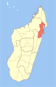
 Sahatavy Location in Madagascar | |
| Coordinates: 17°26′56″S 48°59′43″E | |
| Country | |
| Region | Analanjirofo |
| District | Vavatenina |
| Elevation | 236 m (774 ft) |
| Population (2001)[2] | |
| • Total | 10,000 |
| Time zone | UTC3 (EAT) |
Primary and junior level secondary education are available in town. The majority 95% of the population of the commune are farmers. The most important crop is rice, while other important products are coffee and cloves. Services provide employment for 5% of the population.[2]
References and notes
- Estimated based on DEM data from Shuttle Radar Topography Mission
- "ILO census data". Cornell University. 2002. Retrieved 2008-03-08.
- The Antananarvio Annual and Madagascar Magazine. London Missionary Society Press. 1893. p. 61. Retrieved 9 March 2013.
| Fenerive Est |
|  |
|---|---|---|
| Mananara Nord |
| |
| Maroantsetra |
| |
| Sainte Marie | ||
| Soanierana Ivongo |
| |
| Vavatenina | ||
gollark: Well, we have a fifth of the population, so absent any differences you'd expect a fifth of the rate of police murdering.
gollark: ???
gollark: Well, maybe? I've never interacted with them except for seeing some walking around intimidatingly with guns at the train station for some reason.
gollark: I say keep the death penalty in cases of very obvious and bad things, i.e. acts of terrorism where someone... I don't know, published a manifesto saying "yes I am going to kill some people now", did so and got caught.
gollark: Only TWO of these are related to the justice system.
This article is issued from Wikipedia. The text is licensed under Creative Commons - Attribution - Sharealike. Additional terms may apply for the media files.