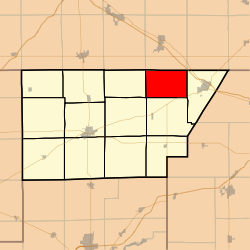
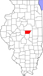
Rutledge Township, DeWitt County, Illinois
Rutledge Township is one of thirteen townships in DeWitt County, Illinois, USA. As of the 2010 census, its population was 177 and it contained 64 housing units.[1] Rutledge Township changed its name from Douglas Township on June 7, 1859.
Rutledge Township | |
|---|---|
 Location in DeWitt County | |
 DeWitt County's location in Illinois | |
| Coordinates: 40°15′32″N 88°45′34″W | |
| Country | |
| State | |
| County | DeWitt |
| Established | November 2, 1858 |
| Area | |
| • Total | 24.43 sq mi (63.3 km2) |
| • Land | 24.41 sq mi (63.2 km2) |
| • Water | 0.02 sq mi (0.05 km2) 0.08% |
| Elevation | 751 ft (229 m) |
| Population (2010) | |
| • Total | 177 |
| • Density | 7.3/sq mi (2.8/km2) |
| Time zone | UTC-6 (CST) |
| • Summer (DST) | UTC-5 (CDT) |
| ZIP codes | 61735, 61752, 61842 |
| GNIS feature ID | 0429689 |
Geography
According to the 2010 census, the township has a total area of 24.43 square miles (63.3 km2), of which 24.41 square miles (63.2 km2) (or 99.92%) is land and 0.02 square miles (0.052 km2) (or 0.08%) is water.[1]
Cemeteries
The township contains the Johnson Cemetery.
School districts
- Blue Ridge Community Unit School District 18
- Clinton Community Unit School District 15
- Le Roy Community Unit School District 2
Political districts
- Illinois's 15th congressional district
- State House District 87
- State Senate District 44
gollark: I have an upside-down mint x tinsel checker which just looks bad due to the right-way-up mints.
gollark: What about upside-down mints showing in lineages?
gollark: If you breed the "CB Prizes" on April Fools' you get an upside-down dragon!
gollark: Pagination, but all the pages are the same.
gollark: We must elect a new TJ09.
References
- "Rutledge Township, DeWitt County, Illinois". Geographic Names Information System. United States Geological Survey. Retrieved 2010-07-06.
- United States Census Bureau 2009 TIGER/Line Shapefiles
- United States National Atlas
- "Population, Housing Units, Area, and Density: 2010 - County -- County Subdivision and Place -- 2010 Census Summary File 1". United States Census. Archived from the original on 2020-02-12. Retrieved 2013-05-28.
External links
This article is issued from Wikipedia. The text is licensed under Creative Commons - Attribution - Sharealike. Additional terms may apply for the media files.