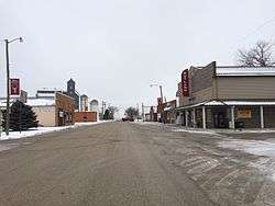
Rutland, North Dakota
Rutland is a city in Sargent County, North Dakota, United States. The population was 163 at the 2010 census.[5] Rutland was founded in 1887.
Rutland, North Dakota | |
|---|---|
 | |
| Motto(s): "Pride of the Prairie" | |
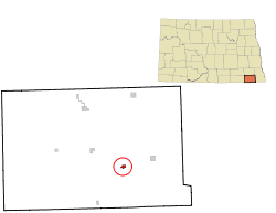 Location of Rutland, North Dakota | |
| Coordinates: 46°3′10″N 97°30′24″W | |
| Country | United States |
| State | North Dakota |
| County | Sargent |
| Area | |
| • Total | 0.39 sq mi (1.00 km2) |
| • Land | 0.39 sq mi (1.00 km2) |
| • Water | 0.00 sq mi (0.00 km2) |
| Elevation | 1,220 ft (372 m) |
| Population | |
| • Total | 163 |
| • Estimate (2019)[3] | 156 |
| • Density | 403.10/sq mi (155.57/km2) |
| Time zone | UTC-6 (Central (CST)) |
| • Summer (DST) | UTC-5 (CDT) |
| ZIP code | 58067 |
| Area code(s) | 701 |
| FIPS code | 38-69340 |
| GNIS feature ID | 1031055[4] |
Geography
Rutland is located at 46°3′10″N 97°30′24″W (46.052670, -97.506656).[6]
According to the United States Census Bureau, the city has a total area of 0.38 square miles (0.98 km2), all of it land.[7]
Demographics
| Historical population | |||
|---|---|---|---|
| Census | Pop. | %± | |
| 1910 | 224 | — | |
| 1920 | 291 | 29.9% | |
| 1930 | 264 | −9.3% | |
| 1940 | 305 | 15.5% | |
| 1950 | 309 | 1.3% | |
| 1960 | 308 | −0.3% | |
| 1970 | 225 | −26.9% | |
| 1980 | 250 | 11.1% | |
| 1990 | 212 | −15.2% | |
| 2000 | 220 | 3.8% | |
| 2010 | 163 | −25.9% | |
| Est. 2019 | 156 | [3] | −4.3% |
| U.S. Decennial Census[8] 2018 Estimate[9] | |||
2010 census
As of the census[2] of 2010, there were 163 people, 84 households, and 46 families residing in the city. The population density was 428.9 inhabitants per square mile (165.6/km2). There were 98 housing units at an average density of 257.9 per square mile (99.6/km2). The racial makeup of the city was 97.5% White, 1.2% Native American, 0.6% Asian, and 0.6% from two or more races.
There were 84 households, of which 26.2% had children under the age of 18 living with them, 47.6% were married couples living together, 6.0% had a female householder with no husband present, 1.2% had a male householder with no wife present, and 45.2% were non-families. 45.2% of all households were made up of individuals, and 15.5% had someone living alone who was 65 years of age or older. The average household size was 1.94 and the average family size was 2.70.
The median age in the city was 48.5 years. 20.2% of residents were under the age of 18; 3.7% were between the ages of 18 and 24; 21.5% were from 25 to 44; 33.8% were from 45 to 64; and 20.9% were 65 years of age or older. The gender makeup of the city was 55.2% male and 44.8% female.
2000 census
As of the census of 2000, there were 220 people, 91 households, and 53 families residing in the city. The population density was 581.3 people per square mile (223.5/km2). There were 102 housing units at an average density of 269.5 per square mile (103.6/km2). The racial makeup of the city was 97.27% White, 1.36% Native American, 0.45% Asian, and 0.91% from two or more races.
There were 91 households, out of which 29.7% had children under the age of 18 living with them, 54.9% were married couples living together, 3.3% had a female householder with no husband present, and 40.7% were non-families. 39.6% of all households were made up of individuals, and 24.2% had someone living alone who was 65 years of age or older. The average household size was 2.42 and the average family size was 3.35.
In the city, the population was spread out, with 33.6% under the age of 18, 2.7% from 18 to 24, 23.6% from 25 to 44, 20.9% from 45 to 64, and 19.1% who were 65 years of age or older. The median age was 38 years. For every 100 females, there were 126.8 males. For every 100 females age 18 and over, there were 105.6 males.
The median income for a household in the city was $26,786, and the median income for a family was $34,167. Males had a median income of $29,375 versus $17,321 for females. The per capita income for the city was $14,064. About 7.1% of families and 20.3% of the population were below the poverty line, including 23.0% of those under the age of eighteen and 38.6% of those 65 or over.
Additional images
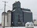 Rutland Farmers' Elevator
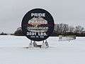 Sign made from the griddle used to cook the World's Largest Hamburger
External links
References
- "2019 U.S. Gazetteer Files". United States Census Bureau. Retrieved July 27, 2020.
- "U.S. Census website". United States Census Bureau. Retrieved 2012-06-14.
- "Population and Housing Unit Estimates". United States Census Bureau. May 24, 2020. Retrieved May 27, 2020.
- "US Board on Geographic Names". United States Geological Survey. October 25, 2007. Retrieved January 31, 2008.
- "2010 Census Redistricting Data (Public Law 94-171) Summary File". American FactFinder. United States Census Bureau. Retrieved May 2, 2011.
- "US Gazetteer files: 2010, 2000, and 1990". United States Census Bureau. February 12, 2011. Retrieved April 23, 2011.
- "US Gazetteer files 2010". United States Census Bureau. Archived from the original on February 20, 2011. Retrieved June 14, 2012.
- United States Census Bureau. "Census of Population and Housing". Retrieved January 30, 2014.
- "Population Estimates". United States Census Bureau. Retrieved July 16, 2019.
Municipalities and communities of Sargent County, North Dakota, United States | ||
|---|---|---|
| Cities | 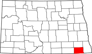 Map of North Dakota highlighting Sargent County | |
| Townships | ||
| CDP | ||
| Unincorporated community |
| |
| Indian reservations | ||
| Footnotes | ‡This populated place also has portions in an adjacent county or counties | |
| Authority control |
|
|---|