Rupa-Rupa
Rupa-Rupa or High Jungle is one of the eight natural regions of Peru. It is located between 400 and 1,000 m above the sea level. This region has many long, narrow valleys and fluvial mountain trails (canyons called pongos). The weather is warm, humid, and rainy.
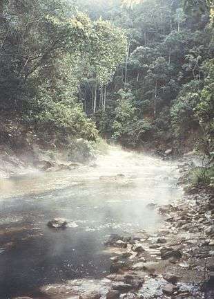
Hot springs in the Rupa-Rupa Region, Amazonas, Peru.
This region has a tropical flora.
The fauna includes the Brazilian Tapir (sachavaca, also called mountain cow), the White-lipped Peccary (huangana), and the Jaguar (otorongo).
Rupa Rupa is the hottest region in Peru.[1]
Overview
Andean Continental Divide
| Westside | Eastside |
|---|---|
| Chala, dry coast | Lowland tropical rainforest or Selva baja |
| Maritime Yungas | Highland tropical rainforest or Selva alta |
| Maritime Yungas | Subtropical cloud forest or Fluvial Yungas |
| Quechua - Montane valleys | Quechua - Montane valleys |
| Tree line | Tree line - about 3,500 m |
| Suni, scrubs and agriculture | Suni, scrubs and agriculture |
Mountain Top:
- Mountain passes - 4,100 m
- Puna grassland
- Andean-alpine desert
- Snow line - about 5,000 m
- Janca - Rocks, Snow and Ice
- Peak
gollark: JavaScript$compilerOutput04$_Z$case
gollark: bee🐝case
gollark: Æ.
gollark: bee\:bee:case
gollark: V4 unfortunately allows bindings.
See also
- Climate zones by altitude
- Altitudinal zonation
Literature
- Pulgar Vidal, Javier: Geografía del Perú; Las Ocho Regiones Naturales del Perú. Edit. Universo S.A., Lima 1979. First Edition (his dissertation of 1940): Las ocho regiones naturales del Perú, Boletín del Museo de historia natural „Javier Prado“, n° especial, Lima, 1941, 17, pp. 145-161.
This article is issued from Wikipedia. The text is licensed under Creative Commons - Attribution - Sharealike. Additional terms may apply for the media files.