Quechua (geography)
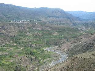
Quechua is one of the eight Natural Regions of Peru and is between 2,300 and 3,500 m above sea level. It is composed of big valleys divided by rivers fed by estival rains.

Valle del Colca, Arequipa, Peru

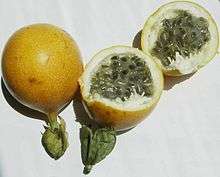
Passion fruit or Granadilla
Its flora includes Andean alder, gongapa, and arracacha. People who live in this region, cultivate corn, squash, passionfruit, papaya, wheat, and peach.
Notable fauna include birds like the chihuanco or white-necked thrush.[1]
Overview
Andean Continental Divide
| Westside | Eastside |
|---|---|
| Chala, dry coast | Lowland tropical rainforest or Selva baja |
| Maritime Yungas | Highland tropical rainforest or Selva alta |
| Maritime Yungas | Subtropical cloud forest or Fluvial Yungas |
| Quechua - Montane valleys | Quechua - Montane valleys |
| Tree line | Tree line - about 3,500 m |
| Suni, scrubs and agriculture | Suni, scrubs and agriculture |
Mountain Top:
- Mountain passes - 4,100 m
- Puna grassland
- Andean-alpine desert
- Snow line - about 5,000 m
- Janca - Rocks, Snow and Ice
- Peak
gollark: I require it for overgraphing purposes.
gollark: It's a metrics gathery thing.
gollark: Prometheus refuses to parse this YAML file because "missing key" even though as far as I can tell each block seems valid.
gollark: *Bee* yaml.
gollark: I can't wait to unnecessarily integrate 1902731897389 things.
See also
- Climate zones by altitude
- Altitudinal zonation
Literature
- Pulgar Vidal, Javier: Geografía del Perú; Las Ocho Regiones Naturales del Perú. Edit. Universo S.A., Lima 1979. First Edition (his dissertation of 1940): Las ocho regiones naturales del Perú, Boletín del Museo de historia natural „Javier Prado“, n° especial, Lima, 1941, 17, pp. 145-161.
This article is issued from Wikipedia. The text is licensed under Creative Commons - Attribution - Sharealike. Additional terms may apply for the media files.