Runswick Bay
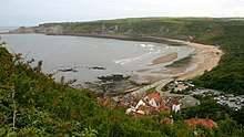
Runswick Bay is a bay in the Scarborough Borough of North Yorkshire, England. It is also the name of a village located on the western edge of the bay (although the village is sometimes shortened to Runswick on UK road signs). It is 5 miles (8 km) north of Whitby, and close to the villages of Ellerby and Hinderwell. It is a popular tourist attraction due to its picturesque cliffside village and Runswick Sands, a white sand beach. It is on the Cleveland Way hiking trail.
| Runswick Bay | |
|---|---|
 Runswick Bay village | |
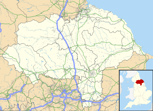 Runswick Bay Location within North Yorkshire | |
| OS grid reference | NZ82171599 |
| Civil parish | |
| District |
|
| Shire county | |
| Region | |
| Country | England |
| Sovereign state | United Kingdom |
| Post town | SALTBURN-BY-THE-SEA |
| Postcode district | TS13 |
| Police | North Yorkshire |
| Fire | North Yorkshire |
| Ambulance | Yorkshire |
| UK Parliament | |
History
The original fishing village was almost completely destroyed by a landslide in 1682. Remarkably, there were no fatalities, as the village was alerted by two mourners at a wake.[1] The village was rebuilt, slightly further to the south, perched on the side of cliffs.
The village ran its own lifeboat from 1866, until it was moved to the RNLI station at Staithes in 1978. The boathouse still remains, and has run its own volunteer rescue boat service since 1982.[2]
In the late 1880s, Runswick Bay was the site of an art colony.[3]
The village is located within the Parish of Hinderwell, which at the 2011 census, had a population of 1,875 people.[4]
Geography
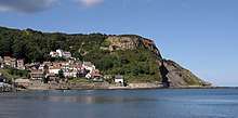
On the north side of the bay is Cauldron Cliff, and the headland on the south side is known as Kettleness, site of alum mining from 1727 until the late 1800s.[5] Around the edge of the bay is a white sand beach called Runswick Sands, and a series of caves. The largest cave on the bay, Hob Hole, was so named as it was believed to be the home of a 'Hob' (or Boggart) in local folklore.[6] The bay is 1.2 miles (2 km) long.[7] A seawall, made of large boulders, was completed in 1970.[1] Like other parts of the Yorkshire Coast, the area suffers from a high degree of coastal erosion which has made it a popular location for fossil hunting.[8]
A number of local streams drain into the bay across Runswick Sands; from West to East: Nettle Dale, Dunsley Dale, Calais Beck and Widgeytoft Gill.[9]
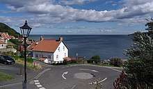
Runswick Bay village covers an area of 620 hectares and has a peak seasonal population of 2,315, though permanent residence is low with a high degree of houses being holiday lets and second homes.[7] It is split into two parts, the 'lower' red-roofed, cliff-side, former-fishing village,[10] and Runswick Bank Top, a hamlet located adjacent to farmland overlooking the bay, built around the intersection of the roads leading to Ellerby and Hinderwell. The Bank Top village contains a camping and Caravan site, a hotel and modern housing developments. The two parts of the village are joined via a steep lane which is part of the Cleveland Way, with the beach located at the bottom of the lane.
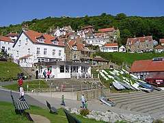
The Lower village of Runswick Bay is densely packed with narrow winding streets and steep steps. It is largely inaccessible to traffic. Key buildings include the old lifeboat station, and a thatched cottage which is a Grade II Listed building.[11] There is a sailing club, a hotel and in summer months, tourists are served by a series of cark parks and a beachside cafe.[12]
References
- Whitworth, Alan (2011). RUNSWICK BAY & STAITHES THROUGH TIME. Amberley. ISBN 9781445605937.
- "Runswick Rescue". Retrieved 23 October 2018.
- Slater, Robert (2010). ARTISTS' COLONIES IN STAITHES AND RUNSWICK BAY c.1880-1914 (PDF). University of Leicester.
- UK Census (2011). "Local Area Report – Hinderwell Parish (1170217346)". Nomis. Office for National Statistics. Retrieved 11 February 2019.
- "Kettleness Alum Works - Tees Valley Wildlife Trust". Tees Valley Wildlife Trust. Retrieved 23 October 2018.
- Whitby. "Whitby Myth and Folklore: Hob - Whitby Online". www.whitbyonline.co.uk. Retrieved 23 October 2018.
- "Runswick Bay Coastal Protection Scheme - non Technical Summary" (PDF). iema.net. July 2017. Retrieved 23 October 2018.
- "Walking with dinosaurs for a stroll along Runswick Bay". Retrieved 23 October 2018.
- Richardson, Gary (2018). 100 Walks in Yorkshire: North York Moors and Wolds. The Crowood Press. ISBN 9781785003868.
- "Runswick Bay - Yorkshire Coast | Welcome to Yorkshire". www.yorkshire.com. Retrieved 23 October 2018.
- Stuff, Good. "The Thatched Cottage, Hinderwell, North Yorkshire". britishlistedbuildings.co.uk. Retrieved 23 October 2018.
- "Runswick Bay: North York Moors National Park". North York Moors National Park. Retrieved 23 October 2018.
External links
| Wikimedia Commons has media related to Runswick Bay. |