Rumoi, Hokkaido
Rumoi (留萌市, Rumoi-shi) is a city located in Rumoi Subprefecture, Hokkaido, Japan. It is the capital of Rumoi Subprefecture.
Rumoi 留萌市 | |
|---|---|
.jpg) Panorama view of Rumoi, from Senboudai | |
 Flag  Emblem | |
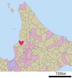
 Location of Rumoi in Hokkaido (Rumoi Subprefecture) | |
 Rumoi Location in Japan | |
| Coordinates: 43°56′N 141°38′E | |
| Country | Japan |
| Region | Hokkaido |
| Prefecture | Hokkaido (Rumoi Subprefecture) |
| Government | |
| • Mayor | Sadatoshi Takahashi |
| Area | |
| • Total | 297.44 km2 (114.84 sq mi) |
| Population (30 September 2016) | |
| • Total | 22,242 |
| • Density | 75/km2 (190/sq mi) |
| Symbols | |
| • Tree | Acacia |
| • Flower | Azalea |
| Time zone | UTC+9 (JST) |
| City hall address | 1-11, Saiwaichō, Rumoi-shi, Hokkaidō 077-8601 |
| Website | www |
As of September 2016, the city has an estimated population of 22,242 and the density of 75 persons per km². The total area is 297.44 km².
History
Rumoi was developed by herring fishery and mining.[1]
- 1869: Rurumoppe was renamed Rumoi.
- 1877: The village of Rumoi was founded.
- 1902: The villages of Rumoi and Reuke were merged to form Rumoi Village.
- 1907: Sandomari village was merged into Rumoi village.
- 1908: Rumoi village became Rumoi town.
- 1914: The capital of Mashike Subprefecture was transferred from Mashike to Rumoi and Mashike Subprefecture was renamed Rumoi Subprefecture.
- 1919: Obirashibe village (now Obira town) was split off.
- 1945 Rumoi was designated as the site of the planned Soviet invasion of Hokkaido, with a plan to occupy the island from Rumoi in the west to Kushiro in the east. The plan was cancelled.[2][3][4]
- 1947: Rumoi town became Rumoi city.
View of Downtown Rumoi from Senbou Hill in night |
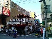
 Andon yatai in Rumoi Dontou Festival on July |
Geography
Rumoi is located in the south of Rumoi Subprefecture. Rumoi River flows through the city.
Climate
Rumoi has a humid continental climate (Köppen climate classification Dfb) with warm summers and cold winters. Precipitation is significant throughout the year, but is heaviest from August to December.
| Climate data for Rumoi | |||||||||||||
|---|---|---|---|---|---|---|---|---|---|---|---|---|---|
| Month | Jan | Feb | Mar | Apr | May | Jun | Jul | Aug | Sep | Oct | Nov | Dec | Year |
| Average high °C (°F) | −1.9 (28.6) |
−1.5 (29.3) |
2.4 (36.3) |
9.2 (48.6) |
14.9 (58.8) |
18.5 (65.3) |
22.6 (72.7) |
24.4 (75.9) |
20.6 (69.1) |
14.5 (58.1) |
7.3 (45.1) |
1.3 (34.3) |
11.0 (51.8) |
| Daily mean °C (°F) | −5.1 (22.8) |
−4.9 (23.2) |
−0.9 (30.4) |
5.2 (41.4) |
10.5 (50.9) |
14.7 (58.5) |
19.0 (66.2) |
20.6 (69.1) |
16.3 (61.3) |
10.3 (50.5) |
3.9 (39.0) |
−1.6 (29.1) |
7.3 (45.2) |
| Average low °C (°F) | −8.8 (16.2) |
−8.9 (16.0) |
−4.7 (23.5) |
1.3 (34.3) |
6.3 (43.3) |
11.3 (52.3) |
16.0 (60.8) |
17.3 (63.1) |
12.1 (53.8) |
6.0 (42.8) |
0.6 (33.1) |
−4.6 (23.7) |
3.7 (38.6) |
| Average precipitation mm (inches) | 108.8 (4.28) |
76.7 (3.02) |
61.0 (2.40) |
53.3 (2.10) |
60.9 (2.40) |
66.0 (2.60) |
94.1 (3.70) |
148.4 (5.84) |
147.1 (5.79) |
142.3 (5.60) |
144.0 (5.67) |
136.7 (5.38) |
1,239.3 (48.78) |
| Average snowfall cm (inches) | 150 (59) |
103 (41) |
57 (22) |
6 (2.4) |
0 (0) |
0 (0) |
0 (0) |
0 (0) |
0 (0) |
1 (0.4) |
36 (14) |
126 (50) |
479 (188.8) |
| Average precipitation days (≥ 1.0 mm) | 21.4 | 17.1 | 14.2 | 9.1 | 9.5 | 8.7 | 8.9 | 10.0 | 12.7 | 15.6 | 19.4 | 22.4 | 169 |
| Average snowy days | 28.0 | 24.1 | 23.5 | 6.8 | 0.3 | 0 | 0 | 0 | 0 | 1.9 | 14.9 | 26.6 | 126.1 |
| Average relative humidity (%) | 77 | 76 | 73 | 71 | 74 | 82 | 83 | 83 | 78 | 73 | 73 | 77 | 77 |
| Mean monthly sunshine hours | 50.6 | 76.6 | 141.2 | 170.8 | 190.4 | 181.9 | 172.7 | 172.5 | 174.7 | 130.1 | 53.5 | 30.2 | 1,545.2 |
| Percent possible sunshine | 18 | 26 | 39 | 43 | 42 | 40 | 37 | 40 | 47 | 38 | 19 | 11 | 35 |
| Source: NOAA (1961–1990)[5] | |||||||||||||
Average wind speed by month
(Annual average: 4.9 m/s or 18 km/h or 11 mph)
| Month | m/s | km/h | mph |
|---|---|---|---|
| January | 6.1 | 22 | 14 |
| February | 5.3 | 19 | 12 |
| March | 4.9 | 18 | 11 |
| April | 4.8 | 17 | 11 |
| May | 4.2 | 15 | 9 |
| June | 3.5 | 13 | 8 |
| July | 3.4 | 12 | 8 |
| August | 3.8 | 14 | 9 |
| September | 4.5 | 16 | 10 |
| October | 5.8 | 21 | 13 |
| November | 6.5 | 23 | 15 |
| December | 6.5 | 23 | 15 |
Transportation
Education
High school
- Hokkaido Rumoi High School
- Hokkaido Rumoi Sembo High School
Sister city
![]()
gollark: And give roles without transferring them.
gollark: You can in fact run events without a role.
gollark: NOBODY suggested that, BEE YOU again.
gollark: ...
gollark: It can be.
References
- The history of Rumoi Archived 2012-09-12 at Archive.today
- Nimmo, William F. "Stars and Stripes Across the Pacific: The United States, Japan, and Asia page 237". Retrieved December 18, 2017.
- Clark, Gregory (August 22, 2014). "How WWII could have ended". Japan Times. Retrieved December 18, 2017.
- Yumashev, Ivan (August 19, 1945). "REPORT BY IVAN YUMASHEV TO ALEKSANDR VASILEVSKY". Retrieved December 18, 2017.
- "Rumoi Climate Normals 1961–1990". National Oceanic and Atmospheric Administration. Retrieved December 29, 2012.
- International exchange of Rumoi Archived 2015-05-29 at Archive.today
External links

- Official Website (in Japanese)
This article is issued from Wikipedia. The text is licensed under Creative Commons - Attribution - Sharealike. Additional terms may apply for the media files.