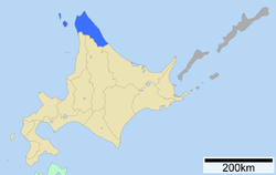
Sōya Subprefecture
Sōya Subprefecture (宗谷総合振興局, Sōya-sōgō-shinkō-kyoku) is a subprefecture of Hokkaido Prefecture, Japan. Its population is estimated to be 77,500 as of July 31, 2004 and its area is 4,050.84 square kilometres (1,564.04 sq mi). It is the northernmost subprefecture of Japan.
Sōya Subprefecture 宗谷総合振興局 | |
|---|---|
| Sōya-sōgō-shinkō-kyoku | |
 | |
| Prefecture | Hokkaido |
| Capital | Wakkanai |
| Area | |
| • Total | 4,050.76 km2 (1,564.01 sq mi) |
| Population (March 2009) | |
| • Total | 75,665 |
| • Density | 19/km2 (48/sq mi) |
| Website | souya.pref.hokkaido.lg.jp |
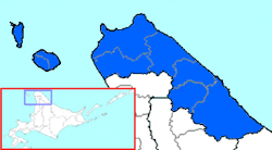
Sōya Subprefecture (without Horonobe)
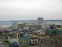
Wakkanai Airport is located in Wakkanai. Rishiri Airport is located in Rishirifuji, Rishiri District.
Geography
Cities
- Wakkanai (capital)
Towns and villages by district
Mergers
History
- 1897: Sōya Subprefecture established; Sōya, Esashi, Rishiri, Rebun Districts placed under its jurisdiction
- 1948: Toyotomi village (now town), Teshio District transferred from Rumoi Subprefecture
- 2010: Horonobe town, Teshio District transferred from Rumoi Subprefecture
gollark: Phases of matter are very general.
gollark: Arguably various gendercrystals.
gollark: Genderboseeinsteincondensateous people, gendersuperconductors, genderemulsions etc.
gollark: There are far more phases of matter than this.
gollark: Inform them that h.
External links
- (in Japanese) Official website
Sapporo (capital) | ||||||||||||
| ||||||||||||
| ||||||||||||
| ||||||||||||
| ||||||||||||
| ||||||||||||
| ||||||||||||
| ||||||||||||
| ||||||||||||
| ||||||||||||
| ||||||||||||
| ||||||||||||
| ||||||||||||
| ||||||||||||
| ||||||||||||
This article is issued from Wikipedia. The text is licensed under Creative Commons - Attribution - Sharealike. Additional terms may apply for the media files.