Roper Highway
The Roper Highway is a road in the Northern Territory of Australia that begins from a point on the Stuart Highway 7 kilometres south of Mataranka, and runs east along the Roper River via Roper Bar to Ngukurr.[1] Its length is 206 kilometres. From Ngukurr the road continues for approximately 153 kilometres to Numbulwar on the Gulf of Carpentaria as the Numbulwar Road.[2] The section of the highway between Roper Bar and Ngukurr is also known as the Ngukurr Access. [3]
Roper Highway | |
|---|---|
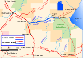 | |
Roper Highway (depicted in blue) | |
| General information | |
| Type | Rural road |
| Length | 206 km (128 mi) |
| Route number(s) | (Mataranka - Ngukurr) |
| Major junctions | |
| SW end | |
| NE end | Ngukurr |
| Location(s) | |
| Major settlements | Elsey, Roper Valley, Roper Bar, Ngukurr |
References
- Transport Infrastructure Planning Division, NT Govt.
- Hema, Maps (2007). Australia Road and 4WD Atlas (Map). Eight Mile Plains Queensland: Hema Maps. pp. 96–97. ISBN 978-1-86500-456-3.
- Department of Transport (April 1998). "Map of all NT Roads" (PDF). Northern Territory Government. Archived from the original (PDF) on 5 May 2013. Retrieved 13 January 2014.
Road infrastructure in Northern Territory | ||
|---|---|---|
| National highways | ||
| Highways | ||
| Major urban roads | ||
| Outback tracks and numbered state routes | ||
This article is issued from Wikipedia. The text is licensed under Creative Commons - Attribution - Sharealike. Additional terms may apply for the media files.