Roche Ronde
Roche Ronde is a 2,138-metre (7,014 ft) mountain summit located at the south end of the Bosche Range in Jasper National Park, in the Canadian Rockies of Alberta, Canada.[2] The peak may be seen from the Jasper House National Historic Site along Highway 16. The mountain was named for the rounded summit as Roche Ronde is French for "round rock".[1][2]
| Roche Ronde | |
|---|---|
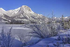 Roche Ronde and its reflection in an open section of the Athabasca River | |
| Highest point | |
| Elevation | 2,138 m (7,014 ft) [1] |
| Prominence | 96 m (315 ft) [2] |
| Parent peak | Mount Aeolus (2643 m)[2] |
| Listing | List of mountains of Alberta |
| Coordinates | 53°13′12″N 118°01′00″W [2] |
| Geography | |
 Roche Ronde Location in Western Alberta | |
| Location | Alberta, Canada |
| Parent range | Bosche Range |
| Topo map | NTS 83E/01 |
Climate
Based on the Köppen climate classification, Roche Ronde is located in a subarctic climate with cold, snowy winters, and mild summers.[3] Temperatures can drop below −20 °C (−4 °F) with wind chill factors below −30 °C (−22 °F). Precipitation runoff from Roche Ronde drains into the Athabasca River.

Roche à Bosche (left) and Roche Ronde (right) with Athabasca River
gollark: You can make a configuration file with the IP and key file in it too so you can just do `ssh mything`.
gollark: The advantage is that a key cannot practically be bruteforced unlike a password.
gollark: Yes.
gollark: Also use SSH key authentication.
gollark: You write code (binary comes up rarely) but it's mostly problem solving. Breaking up problems into things the computer can actually run.
See also
References
- "Roche Ronde". PeakFinder.com. Retrieved 2009-11-06.
- "Roche Ronde". Bivouac.com. Retrieved 2019-07-24.
- Peel, M. C.; Finlayson, B. L. & McMahon, T. A. (2007). "Updated world map of the Köppen−Geiger climate classification". Hydrol. Earth Syst. Sci. 11: 1633–1644. ISSN 1027-5606.
External links
- Parks Canada web site: Jasper National Park
This article is issued from Wikipedia. The text is licensed under Creative Commons - Attribution - Sharealike. Additional terms may apply for the media files.