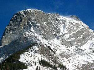
Roche à Perdrix
Roche à Perdrix is a mountain in Alberta's Rockies, Canada.
| Roche à Perdrix | |
|---|---|
 | |
| Highest point | |
| Elevation | 2,135 m (7,005 ft) [1] |
| Prominence | 168 m (551 ft) [2] |
| Coordinates | 53°12′45″N 117°48′10″W |
| Geography | |
 Roche à Perdrix Location of Roche à Perdrix in Alberta  Roche à Perdrix Roche à Perdrix (Canada) | |
| Location | Alberta, Canada |
| Parent range | Fiddle Range |
| Topo map | NTS 83F/04 |
| Climbing | |
| Easiest route | moderate scramble |
It is located south of Highway 16 on the eastern border of Jasper National Park, and is part of the Fiddle Range, one of the easternmost ranges of the Canadian Rockies. It is one of the first mountains upon entering the park from the east and is directly on the park border. In French, perdrix means partridge and roche means rock. The name is a reference to the rock foliations, which resemble a partridge's tail feathers.[1]
It was named by the Reverend George Grant in 1872. [3]
Climate
Based on the Köppen climate classification, it is located in a subarctic climate with cold, snowy winters, and mild summers.[4] Temperatures can drop below -20 °C with wind chill factors below -30 °C. In terms of favorable weather, June through September are the best months to climb. Precipitation runoff from the mountain flows into the Athabasca River.
References
- PeakFinder. "Roche à Perdrix". Retrieved 2007-09-01.
- "Roche a Perdrix". Bivouac.com. Retrieved 2009-01-02.
- Birrell, Dave (2000). 50 Roadside Panoramas in the Canadian Rockies. Rocky Mountain Books. ISBN 0-921102-65-8.
- Peel, M. C.; Finlayson, B. L. & McMahon, T. A. (2007). "Updated world map of the Köppen−Geiger climate classification". Hydrol. Earth Syst. Sci. 11: 1633–1644. ISSN 1027-5606.
_I_climbed_the_left_ridge_to_the_summit_with_Graeme_Hynd_in_68-09-10_-_(28529944330).jpg)