Robinson Township, Brown County, Kansas
Robinson Township is a township in Brown County, Kansas, USA. As of the 2000 census, its population was 452.
Robinson Township | |
|---|---|
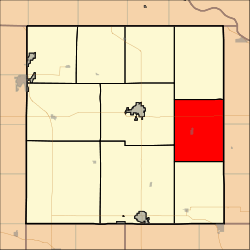 Location in Brown County | |
| Coordinates: 39°49′16″N 095°24′31″W | |
| Country | United States |
| State | Kansas |
| County | Brown |
| Area | |
| • Total | 44.87 sq mi (116.22 km2) |
| • Land | 44.76 sq mi (115.92 km2) |
| • Water | 0.11 sq mi (0.29 km2) 0.25% |
| Elevation | 1,010 ft (308 m) |
| Population (2000) | |
| • Total | 452 |
| • Density | 10.1/sq mi (3.9/km2) |
| GNIS feature ID | 0472990 |
Geography
Robinson Township covers an area of 44.87 square miles (116.2 km2) and contains one incorporated settlement, Robinson. According to the USGS, it contains two cemeteries: Rose Hill and Ununda.
The streams of Buttermilk Creek, Middle Fork Wolf River and South Fork Wolf River run through this township.
gollark: If you want guarantees use your own stuff.
gollark: Operation is not guaranteed. Not having data loss is not guaranteed.
gollark: I should be able to maintain operation of some sort for a year, yes, why?
gollark: Nobody
gollark: That... is quite a weird sort of limitation.
External links
Municipalities and communities of Brown County, Kansas, United States | ||
|---|---|---|
| Cities |  Map of Kansas highlighting Brown County | |
| CDPs | ||
| Unincorporated communities | ||
| Indian reservations | ||
| Townships | ||
| Footnotes | ‡This populated place also has portions in an adjacent county or counties | |
This article is issued from Wikipedia. The text is licensed under Creative Commons - Attribution - Sharealike. Additional terms may apply for the media files.