Ro, Emilia-Romagna
Ro (Ferrarese: Rò) is a comune (municipality) in the Province of Ferrara in the Italian region Emilia-Romagna, located about 60 kilometres (37 mi) northeast of Bologna and about 15 kilometres (9 mi) northeast of Ferrara. As of 31 December 2004, it had a population of 3,663 and an area of 43.0 square kilometres (16.6 sq mi).[3]
Ro | |
|---|---|
| Comune di Ro | |
Location of Ro 
| |
 Ro Location of Ro in Italy 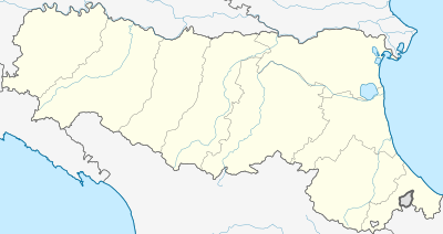 Ro Ro (Emilia-Romagna) | |
| Coordinates: 44°56′N 11°45′E | |
| Country | Italy |
| Region | Emilia-Romagna |
| Province | Province of Ferrara (FE) |
| Frazioni | Alberone, Guarda, Ruina, Zocca |
| Area | |
| • Total | 43.0 km2 (16.6 sq mi) |
| Elevation | 5 m (16 ft) |
| Population (Dec. 2004)[2] | |
| • Total | 3,663 |
| • Density | 85/km2 (220/sq mi) |
| Time zone | UTC+1 (CET) |
| • Summer (DST) | UTC+2 (CEST) |
| Postal code | 44030 |
| Dialing code | 0532 |
| Website | Official website |
The municipality of Ro contains the frazioni (subdivisions, mainly villages and hamlets) Alberone, Guarda, Ruina, and Zocca.
Ro borders the following municipalities: Berra, Canaro, Copparo, Crespino, Ferrara, Guarda Veneta, Polesella.
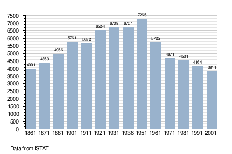
Demographic evolution
gollark: Detection of mass anomalies in certain gauge bosons. They couple with the gay field, so high-energy disturbances in it can be measured.
gollark: You have a bot, you implement it.
gollark: It would need to scan embeds too, and bee you arcane.
gollark: Yes, I know, I can't be bothered to add that to ABR.
gollark: Technically yes but I can't be bothered.
References
- "Superficie di Comuni Province e Regioni italiane al 9 ottobre 2011". Istat. Retrieved 16 March 2019.
- "Popolazione Residente al 1° Gennaio 2018". Istat. Retrieved 16 March 2019.
- All demographics and other statistics: Italian statistical institute Istat.
This article is issued from Wikipedia. The text is licensed under Creative Commons - Attribution - Sharealike. Additional terms may apply for the media files.