Rittenhouse Army Heliport
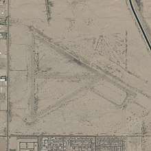
Rittenhouse Army Heliport (FAA LID: AZ38) formally Williams Field Auxiliary No. 2 is an Arizona Army National Guard training airstrip 11.5 miles (10.0 nmi; 18.5 km) east of the central business district of Queen Creek, a city in Pinal County, Arizona, United States and 31 miles (27 nmi; 50 km) southeast of Phoenix Sky Harbor International Airport.[1]
Rittenhouse Army Heliport Williams Field Auxiliary No. 2 | |||||||||||
|---|---|---|---|---|---|---|---|---|---|---|---|
 | |||||||||||
| Summary | |||||||||||
| Airport type | Military | ||||||||||
| Owner | United States Army | ||||||||||
| Operator | Arizona Army National Guard | ||||||||||
| Location | Queen Creek, Arizona | ||||||||||
| Elevation AMSL | 1,550 ft / 472 m | ||||||||||
| Coordinates | 33°15′05″N 111°31′05″W | ||||||||||
| Map | |||||||||||
 AZ38  AZ38 | |||||||||||
| Runways | |||||||||||
| |||||||||||
| Statistics | |||||||||||
| |||||||||||
Source: Federal Aviation Administration | |||||||||||
Although Most U.S. airports use the same three-letter location identifier for the FAA, IATA, and ICAO, this airport is only assigned AZ38 by the FAA.[2]
Williams Field Auxiliary No. 2 was one of many auxiliary fields that served Williams Field (now Phoenix-Mesa Gateway Airport) and is one of many Arizona World War II Army Airfields.[3]
Facilities and aircraft
Rittenhouse Army Heliport is at an elevation of 1,550 ft (470 m) above mean sea level. It has one asphalt runway:
- 12/30 measuring 1,500 ft × 50 ft (457 m × 15 m)[4]
No aircraft are based at this airfield.
References
- "AirportIQ 5010". www.gcr1.com. Retrieved 2018-06-15.
- "AZ38 – Queen Creek [Rittenhouse Army Heliport], AZ, US – Heliport – Great Circle Mapper". www.gcmap.com. Retrieved 2018-06-15.
- "Abandoned & Little-Known Airfields: Arizona: Southeastern Phoenix". www.airfields-freeman.com. Retrieved 2018-06-15.
- "AOPA Airports". www.aopa.org. Retrieved 2018-06-15.
External links
- Resources for this airport:
- FAA airport information for AZ38
- AirNav airport information for KAZ38
- FlightAware airport information and live flight tracker
- NOAA/NWS weather observations: current, past three days
- SkyVector aeronautical chart, Terminal Procedures