Bisbee Douglas International Airport
Bisbee Douglas International Airport (IATA: DUG, ICAO: KDUG, FAA LID: DUG) is a county-owned airport 9 miles (7.8 nmi; 14 km) northwest of Douglas[1] and 17 miles (15 nmi; 27 km) east of Bisbee, both in Cochise County, Arizona.[1] The FAA's National Plan of Integrated Airport Systems for 2009–2013 categorizes it as a general aviation facility.[2]
Bisbee Douglas International Airport | |||||||||||||||
|---|---|---|---|---|---|---|---|---|---|---|---|---|---|---|---|
| Summary | |||||||||||||||
| Airport type | Public | ||||||||||||||
| Owner | Cochise County | ||||||||||||||
| Serves | Douglas & Bisbee, Arizona | ||||||||||||||
| Elevation AMSL | 4,150 ft / 1,265 m | ||||||||||||||
| Coordinates | 31°28′08″N 109°36′13″W | ||||||||||||||
| Map | |||||||||||||||
 DUG  DUG | |||||||||||||||
| Runways | |||||||||||||||
| |||||||||||||||
| Statistics (2009) | |||||||||||||||
| |||||||||||||||

History
World War II
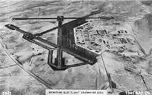
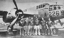
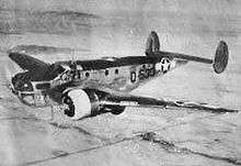
Bisbee Douglas International Airport was originally constructed during World War II as a U.S. Army Air Forces installation known as Douglas Army Airfield. Douglas AAF conducted advanced training in the AT-9 Jeep, AT-17 BobcT, and C-45 Expeditor training aircraft and the B-25 Mitchell bomber.[3]
In addition to Douglas Army Airfield, five auxiliary airfields were constructed in the area for emergency and overflow use:
- McNeal Field (Aux #1) 31°36′21″N 109°39′09″W
- Forrest Field (Aux #2) 31°22′27″N 109°40′30″W
- Webb Coutland (Elfrida) Field (Aux #3) 31°46′24″N 109°41′49″W
- Auxiliary Field 4 is unknown
- Hereford Army Airfield (Aux #5) 31°24′57″N 110°08′51″W
Post-war
With the end of World War II, Douglas AAF was considered surplus to military needs and was transferred to local government authorities of the City of Douglas for conversion to a civilian airport. American Airlines served the airport before being replaced by Apache Airlines, a commuter air carrier, in 1965. Bisbee/Douglas was part of a transcontinental multi-stop route operated by American in 1959 with Douglas DC-6 propliners with daily flights in each direction between the east coast and the west coast. The westbound routing was New York Newark (EWR) - Philadelphia (PHL) - Washington D.C. (DCA) - Memphis (MEM) - Fort Worth (GSW) - El Paso (ELP) - Bisbee/Douglas (DUG) - Tucson (TUS) - Phoenix (PHX) - San Diego (SAN) - Los Angeles (LAX).[4] By 1963, American was still serving the airport with two daily flights operated with the DC-6. The westbound routing was Dallas (DAL) - Midland/Odessa (MAF) - El Paso - Bisbee/Douglas - Tucson - Phoenix - San Diego - Los Angeles.[5] Scheduled passenger flights ended in 1975.
Facilities
The airport covers 3,000 acres (1,200 ha) at an elevation of 4,154 feet (1,266 m). It has two asphalt runways: 17/35 is 7,311 by 100 feet (2,228 x 30 m) and 8/26 is 5,000 by 75 feet (1,524 x 23 m).[1]
In the year ending March 31, 2009 the airport had 19,650 aircraft operations, average 53 per day: 71% general aviation and 29% military. 19 aircraft were then based at the airport: 95% single-engine and 5% multi-engine.[1]
References
- FAA Airport Master Record for DUG (Form 5010 PDF). Federal Aviation Administration. Effective 29 July 2010.
- National Plan of Integrated Airport Systems for 2009–2013: Appendix A: Part 1 (PDF, 1.33 MB) Archived August 6, 2011, at the Wayback Machine. Federal Aviation Administration. Updated 15 October 2008.
- https://web.archive.org/web/20120607234703/http://www.chrismcdoniel.com/P-38/Dougas_Field.html
- http://www.timetableimages.com, Oct. 25, 1959 American Airlines system timetable
- http://www.timetableimages.com, June 1, 1963 American Airlines system timetable
| Wikimedia Commons has media related to Douglas Army Airfield (Arizona). |
![]()
- Shaw, Frederick J. (2004), Locating Air Force Base Sites History's Legacy, Air Force History and Museums Program, United States Air Force, Washington DC, 2004.
- Manning, Thomas A. (2005), History of Air Education and Training Command, 1942–2002. Office of History and Research, Headquarters, AETC, Randolph AFB, Texas ASIN: B000NYX3PC
External links
- Douglas Army Airfield in World War II
- Bisbee ~ Douglas International Airport (DUG) at Arizona DOT airport directory
- Aerial image as of 8 October 1996 from USGS The National Map
- Resources for this airport:
- FAA airport information for DGL
- AirNav airport information for DGL
- ASN accident history for DGL
- FlightAware airport information and live flight tracker
- SkyVector aeronautical chart for DGL
| Flying Training |
|  | ||||
|---|---|---|---|---|---|---|
| Technical Training |
| |||||